Home > Popular Themes > Olympics
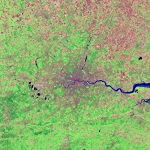
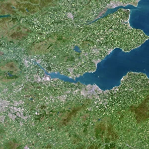
South East England, satellite image

![]()
Wall Art and Photo Gifts from Science Photo Library
South East England, satellite image
South East England. 15 metre resolution satellite image of South East England. London, the capital city of the UK, is at left centre. The River Thames flows through London to the North Sea (right). The Essex coast is seen above the Thames Estuary and the Kent coast below it. Image taken on the 29th October 2012
Science Photo Library features Science and Medical images including photos and illustrations
Media ID 9208515
© PLANETOBSERVER/SCIENCE PHOTO LIBRARY
Capital City Coast Coastal Coastline Earth Observation East Sussex Essex Hertfordshire Kent Land London North Sea River River Thames Satellite Satellite Image South East Surrey Sussex Thames Estuary West Sussex Heathrow Airport Olympic Park Olympic Stadium
EDITORS COMMENTS
This stunning satellite image captures the breathtaking beauty of South East England, showcasing its diverse landscape and iconic landmarks. Taken on October 29th, 2012, this high-resolution print provides a bird's-eye view of this region. At the heart of the image lies London, the bustling capital city of the United Kingdom. With its unmistakable skyline and rich history, it stands proudly at left center. The majestic River Thames gracefully winds its way through London before flowing into the North Sea on the right side of the photo. As we explore further, our eyes are drawn to the enchanting Essex coast above the Thames Estuary and Kent's picturesque coastline below it. These coastal areas exhibit their own unique charm and offer endless opportunities for leisurely walks along sandy shores or exploring quaint seaside towns. Notably visible in this image are prominent airports like Heathrow Airport and Gatwick Airport, serving as gateways to both domestic and international destinations. Additionally, we catch a glimpse of Olympic Park with its iconic stadium—a testament to London hosting an unforgettable Summer Olympics in 2012. This satellite image is not just a visual masterpiece; it also serves as a valuable tool for geographical analysis and Earth observation. It showcases how technology can provide us with invaluable insights into our world from above—capturing moments frozen in time for generations to appreciate.
MADE IN THE UK
Safe Shipping with 30 Day Money Back Guarantee
FREE PERSONALISATION*
We are proud to offer a range of customisation features including Personalised Captions, Color Filters and Picture Zoom Tools
SECURE PAYMENTS
We happily accept a wide range of payment options so you can pay for the things you need in the way that is most convenient for you
* Options may vary by product and licensing agreement. Zoomed Pictures can be adjusted in the Basket.