Premium Framed Print > Universal Images Group (UIG) > Universal Images Group > Satellite and Aerial > Planet Observer 4
Premium Framed Print : Sweden, Relief Map with Border and Mask


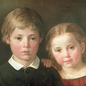
![]()
Framed Photos from Universal Images Group (UIG)
Sweden, Relief Map with Border and Mask
Relief map of Sweden (with border and mask). This image was compiled from data acquired by landsat 5 & 7 satellites combined with elevation data
Universal Images Group (UIG) manages distribution for many leading specialist agencies worldwide
Media ID 9618645
© Planet Observer/UIG
Baltic Sea Coastline Relief Map Scandinavia Shore Stockholm Sweden Satellite View
17"x15" (43x38cm) Premium Frame
FSC real wood frame with double mounted 10x8 print. Double mounted with white conservation mountboard. Frame moulding comprises stained composite natural wood veneers (Finger Jointed Pine) 39mm wide by 21mm thick. Archival quality Fujifilm CA photo paper mounted onto 1mm card. Overall outside dimensions are 17x15 inches (431x381mm). Rear features Framing tape to cover staples, 50mm Hanger plate, cork bumpers. Glazed with durable thick 2mm Acrylic to provide a virtually unbreakable glass-like finish. Acrylic Glass is far safer, more flexible and much lighter than typical mineral glass. Moreover, its higher translucency makes it a perfect carrier for photo prints. Acrylic allows a little more light to penetrate the surface than conventional glass and absorbs UV rays so that the image and the picture quality doesn't suffer under direct sunlight even after many years. Easily cleaned with a damp cloth. Please note that, to prevent the paper falling through the mount window and to prevent cropping of the original artwork, the visible print may be slightly smaller to allow the paper to be securely attached to the mount without any white edging showing and to match the aspect ratio of the original artwork.
FSC Real Wood Frame and Double Mounted with White Conservation Mountboard - Professionally Made and Ready to Hang
Estimated Image Size (if not cropped) is 17.3cm x 24.4cm (6.8" x 9.6")
Estimated Product Size is 38.1cm x 43.1cm (15" x 17")
These are individually made so all sizes are approximate
Artwork printed orientated as per the preview above, with portrait (vertical) orientation to match the source image.
EDITORS COMMENTS
This stunning print showcases the breathtaking beauty of Sweden's topography. With intricate details and vibrant colors, this relief map captures the essence of Scandinavia's largest country. Compiled from data acquired by Landsat 5 & 7 satellites combined with elevation data, this image offers a unique perspective on Sweden's physical geography. The border and mask surrounding the relief map add an artistic touch to the photograph, enhancing its visual appeal. From Stockholm to the Arctic Polar Circle, every inch of coastline is meticulously depicted, allowing viewers to appreciate the diverse landscapes that make up this Nordic nation. The Baltic Sea glistens in shades of blue, contrasting against lush green forests and snow-capped mountains. This satellite view provides a comprehensive overview of Sweden's natural wonders without any human presence in sight. Whether you are an avid cartography enthusiast or simply fascinated by Europe's geographical diversity, this print is sure to captivate your imagination. Hang it on your wall and let it transport you to the enchanting world of Swedish landscapes – a true testament to Mother Nature's artistry
MADE IN THE UK
Safe Shipping with 30 Day Money Back Guarantee
FREE PERSONALISATION*
We are proud to offer a range of customisation features including Personalised Captions, Color Filters and Picture Zoom Tools
SECURE PAYMENTS
We happily accept a wide range of payment options so you can pay for the things you need in the way that is most convenient for you
* Options may vary by product and licensing agreement. Zoomed Pictures can be adjusted in the Basket.