Premium Framed Print > Europe > United Kingdom > England > London > Art > Paintings
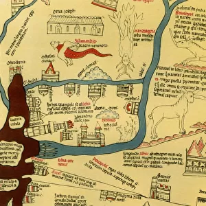
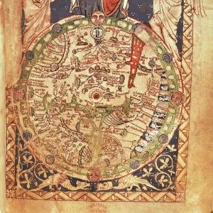
Premium Framed Print : Mappa Mundi, ink and colors on parchment, created in London about 1265


![]()
Framed Photos from Universal Images Group (UIG)
Mappa Mundi, ink and colors on parchment, created in London about 1265
Cartography, 13th century. Mappa Mundi, Medieval map, London about 1265. Ink and colors on parchment. The maps diameter is 9 cm
Universal Images Group (UIG) manages distribution for many leading specialist agencies worldwide
Media ID 9501673
© DEA PICTURE LIBRARY
13th Century Angel Anthropomorphic Direction Globe Guidance Ink Drawing Looking At Camera Medieval Mixed Media Simplicity Western Script
17"x15" (43x38cm) Premium Frame
FSC real wood frame with double mounted 10x8 print. Double mounted with white conservation mountboard. Frame moulding comprises stained composite natural wood veneers (Finger Jointed Pine) 39mm wide by 21mm thick. Archival quality Fujifilm CA photo paper mounted onto 1mm card. Overall outside dimensions are 17x15 inches (431x381mm). Rear features Framing tape to cover staples, 50mm Hanger plate, cork bumpers. Glazed with durable thick 2mm Acrylic to provide a virtually unbreakable glass-like finish. Acrylic Glass is far safer, more flexible and much lighter than typical mineral glass. Moreover, its higher translucency makes it a perfect carrier for photo prints. Acrylic allows a little more light to penetrate the surface than conventional glass and absorbs UV rays so that the image and the picture quality doesn't suffer under direct sunlight even after many years. Easily cleaned with a damp cloth. Please note that, to prevent the paper falling through the mount window and to prevent cropping of the original artwork, the visible print may be slightly smaller to allow the paper to be securely attached to the mount without any white edging showing and to match the aspect ratio of the original artwork.
FSC Real Wood Frame and Double Mounted with White Conservation Mountboard - Professionally Made and Ready to Hang
Estimated Image Size (if not cropped) is 18.3cm x 24.4cm (7.2" x 9.6")
Estimated Product Size is 38.1cm x 43.1cm (15" x 17")
These are individually made so all sizes are approximate
Artwork printed orientated as per the preview above, with portrait (vertical) orientation to match the source image.
FEATURES IN THESE COLLECTIONS
> Arts
> Art Movements
> Medieval Art
> Arts
> Contemporary art
> Mixed media
> Paintings
> Arts
> Still life artwork
> Mixed media artworks
> Portraits
> Arts
> Portraits
> Mixed media artwork
> Arts
> Realistic drawings
> Portrait drawings
> Fine art
> Arts
> Street art graffiti
> Portrait paintings
> Mixed media artwork
> Europe
> United Kingdom
> England
> London
> Art
> Paintings
> Maps and Charts
> Related Images
> Popular Themes
> Maps and Charts
> Posters
> Scientific Posters
> Universal Images Group (UIG)
> Art
> Painting, Sculpture & Prints
> Illustration And Painting
EDITORS COMMENTS
This print showcases the remarkable "Mappa Mundi" a medieval map created in London around 1265. Crafted with ink and colors on parchment, this intricate piece of cartography measures approximately 9 cm in diameter. The portrait-style image captures the essence of this historical artifact, which serves as a testament to the ingenuity and artistry of its time. The Mappa Mundi is an awe-inspiring depiction of physical geography, offering insights into how people perceived the world during the 13th century. Its anthropomorphic elements, such as angelic figures and divine symbolism, add a touch of mystique to its overall design. This fine art painting draws inspiration from Byzantine style while incorporating Western script for labeling purposes. With no people present in the image, one can focus solely on admiring the intricacies within this masterpiece. The simplicity yet complexity of its design invites viewers to ponder upon its purpose: providing guidance for travelers or serving as a visual representation of history itself. As we gaze at this vertical composition, it feels as though we are looking directly into history's eyes. It reminds us that even centuries ago, humans sought direction and understanding through maps – seeking God's guidance in their journeys across uncharted territories
MADE IN THE UK
Safe Shipping with 30 Day Money Back Guarantee
FREE PERSONALISATION*
We are proud to offer a range of customisation features including Personalised Captions, Color Filters and Picture Zoom Tools
SECURE PAYMENTS
We happily accept a wide range of payment options so you can pay for the things you need in the way that is most convenient for you
* Options may vary by product and licensing agreement. Zoomed Pictures can be adjusted in the Basket.