Premium Framed Print > Europe > United Kingdom > England > London > Museums > London Canal Museum
Premium Framed Print : First geological map of Britain, 1815 C016 / 5681


![]()
Framed Photos from Science Photo Library
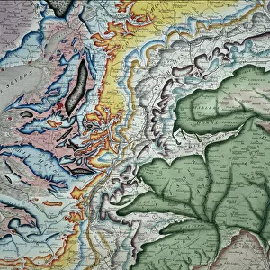
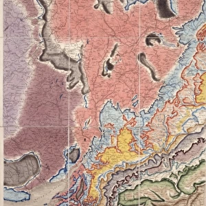
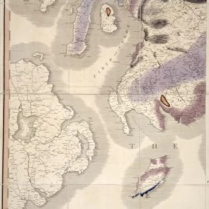
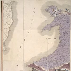
First geological map of Britain, 1815 C016 / 5681
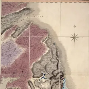
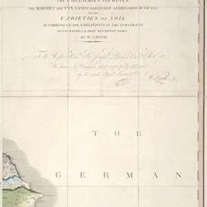
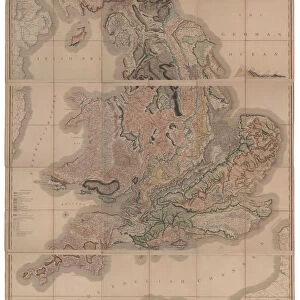
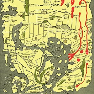
First geological map of Britain, detail of the South East of England (figure 6). This map was published in 1815 by British geologist William Smith (1769-1839). It shows rock layers (strata) in England and Wales and part of Scotland (key at lower left). Smiths work as a canal surveyor allowed him to study geology. He discovered that geological strata could be reliably identified at different places on the basis of the fossils they contained. Smith also proposed the principle of superposition, that if a strata overlays another then it was laid down at a later time. He is considered the father of English geology
Science Photo Library features Science and Medical images including photos and illustrations
Media ID 9206567
© NATURAL HISTORY MUSEUM, LONDON/SCIENCE PHOTO LIBRARY
1815 Cartography Country Earth Science English Channel Geological Great Britain Pioneering Region Scottish South East Strata Stratigraphy Stratum Superposition Welsh William Smith South Downs
23"x19" (58x48cm) Premium Frame
FSC real wood frame with double mounted 16x12 print. Double mounted with white conservation mountboard. Frame moulding comprises stained composite natural wood veneers (Finger Jointed Pine) 39mm wide by 21mm thick. Archival quality Fujifilm CA photo paper mounted onto 1mm card. Overall outside dimensions are 23x19 inches (584x482mm). Rear features Framing tape to cover staples, 50mm Hanger plate, cork bumpers. Glazed with durable thick 2mm Acrylic to provide a virtually unbreakable glass-like finish. Acrylic Glass is far safer, more flexible and much lighter than typical mineral glass. Moreover, its higher translucency makes it a perfect carrier for photo prints. Acrylic allows a little more light to penetrate the surface than conventional glass and absorbs UV rays so that the image and the picture quality doesn't suffer under direct sunlight even after many years. Easily cleaned with a damp cloth. Please note that, to prevent the paper falling through the mount window and to prevent cropping of the original artwork, the visible print may be slightly smaller to allow the paper to be securely attached to the mount without any white edging showing and to match the aspect ratio of the original artwork.
FSC Real Wood Frame and Double Mounted with White Conservation Mountboard - Professionally Made and Ready to Hang
Estimated Image Size (if not cropped) is 23.2cm x 39.6cm (9.1" x 15.6")
Estimated Product Size is 48.2cm x 58.4cm (19" x 23")
These are individually made so all sizes are approximate
Artwork printed orientated as per the preview above, with portrait (vertical) orientation to match the source image.
FEATURES IN THESE COLLECTIONS
> Asia
> East Timor
> Maps
> Asia
> East Timor
> Related Images
> Europe
> United Kingdom
> England
> London
> Museums
> British Library
> Europe
> United Kingdom
> England
> London
> Museums
> British Museum
> Europe
> United Kingdom
> England
> London
> Museums
> London Canal Museum
> Europe
> United Kingdom
> England
> London
> Museums
> Natural History Museum
> Europe
> United Kingdom
> England
> London
> Museums
> Science Museum
> Europe
> United Kingdom
> England
> London
> Sights
> British Museum
> Europe
> United Kingdom
> England
> London
> Sights
> London Canal Museum
> Europe
> United Kingdom
> England
> London
> Towns
> Lower Place
EDITORS COMMENTS
This print showcases the first geological map of Britain, a groundbreaking work published in 1815 by British geologist William Smith. The map, which is a detailed depiction of the South East of England (figure 6), offers a glimpse into the rich history and geological composition of this region. William Smith's remarkable contribution to geology stemmed from his career as a canal surveyor, allowing him to closely study the Earth's strata. Through meticulous observations, he discovered that different rock layers could be reliably identified based on the fossils they contained. This revolutionary insight laid the foundation for stratigraphy and established Smith as the father of English geology. The map itself provides an intricate illustration of England and Wales, along with parts of Scotland. It includes key information about various rock layers or strata found across these regions, offering valuable insights into their geological makeup. Smith also proposed the principle of superposition, suggesting that if one layer overlays another, it was deposited at a later time. This concept revolutionized our understanding of Earth's history and continues to shape modern geological studies. As we delve into this historical masterpiece created almost two centuries ago, we are reminded not only of its pioneering significance but also its artistic beauty. The intricate cartography captures both scientific accuracy and aesthetic appeal—a testament to William Smith's genius as well as his dedication to unraveling Earth's mysteries through artistry and science combined.
MADE IN THE UK
Safe Shipping with 30 Day Money Back Guarantee
FREE PERSONALISATION*
We are proud to offer a range of customisation features including Personalised Captions, Color Filters and Picture Zoom Tools
SECURE PAYMENTS
We happily accept a wide range of payment options so you can pay for the things you need in the way that is most convenient for you
* Options may vary by product and licensing agreement. Zoomed Pictures can be adjusted in the Basket.