Premium Framed Print > Animals > Fishes > Related Images
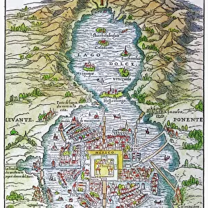
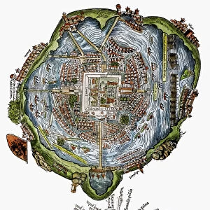
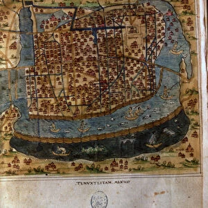
Premium Framed Print : Map of Tenochtitlan. Mexico, 1560. By Alonso de Santa Cruz


![]()
Framed Photos from Mary Evans Picture Library
Map of Tenochtitlan. Mexico, 1560. By Alonso de Santa Cruz
Map of Tenochtitlan. Mexico, 1560. General islario of all the islands in the world. Work of the chronicler and cosmographer Alonso de Santa Cruz (1505-1567). National Library. Madrid. Spain
Mary Evans Picture Library makes available wonderful images created for people to enjoy over the centuries
Media ID 14319317
© Thaliastock / Mary Evans
Alonso Alonzo Aztec Cartography Cruz Geography Latin Mapping Mexican Mexico Tenochtitlan Texcoco
17"x15" (43x38cm) Premium Frame
FSC real wood frame with double mounted 10x8 print. Double mounted with white conservation mountboard. Frame moulding comprises stained composite natural wood veneers (Finger Jointed Pine) 39mm wide by 21mm thick. Archival quality Fujifilm CA photo paper mounted onto 1mm card. Overall outside dimensions are 17x15 inches (431x381mm). Rear features Framing tape to cover staples, 50mm Hanger plate, cork bumpers. Glazed with durable thick 2mm Acrylic to provide a virtually unbreakable glass-like finish. Acrylic Glass is far safer, more flexible and much lighter than typical mineral glass. Moreover, its higher translucency makes it a perfect carrier for photo prints. Acrylic allows a little more light to penetrate the surface than conventional glass and absorbs UV rays so that the image and the picture quality doesn't suffer under direct sunlight even after many years. Easily cleaned with a damp cloth. Please note that, to prevent the paper falling through the mount window and to prevent cropping of the original artwork, the visible print may be slightly smaller to allow the paper to be securely attached to the mount without any white edging showing and to match the aspect ratio of the original artwork.
FSC Real Wood Frame and Double Mounted with White Conservation Mountboard - Professionally Made and Ready to Hang
Estimated Image Size (if not cropped) is 21.8cm x 24.4cm (8.6" x 9.6")
Estimated Product Size is 38.1cm x 43.1cm (15" x 17")
These are individually made so all sizes are approximate
Artwork printed orientated as per the preview above, with portrait (vertical) orientation to match the source image.
FEATURES IN THESE COLLECTIONS
> Animals
> Fishes
> Related Images
> Animals
> Mammals
> Cricetidae
> Santa Cruz Mouse
> Europe
> Spain
> Related Images
> Maps and Charts
> Early Maps
EDITORS COMMENTS
This stunning 16th-century map, titled "Map of Tenochtitlan. Mexico. General Islario of All the Islands in the World," is a testament to the remarkable cartographic achievements of the Spanish explorers during the Age of Discovery. Created by the chronicler and cosmographer Alonso de Santa Cruz (1505-1567), this map offers a unique perspective into the geographical knowledge of the New World during this period. The map centers on the Valley of Mexico, with Tenochtitlan, the Aztec capital city, prominently depicted in the center. The map also includes the surrounding areas, including Texcoco and other lake cities. The lake itself, with its intricate network of canals and islands, is depicted with remarkable detail, reflecting the importance of water transportation in the region. The map is part of a larger work known as the "Islario," a comprehensive atlas of the world's islands. The map's title suggests that Santa Cruz intended to include the islands of the Caribbean and the Pacific in his work, reflecting the expanding horizons of Spanish exploration. The map is rich in detail, with various symbols denoting different features, such as fish to represent bodies of water and boats to indicate ports. The map also includes Latin place names, reflecting the European influence on the naming of places in the New World. The intricate detail and accuracy of this map are a reflection of the advanced cartographic techniques of the time, which relied on a combination of observation, local knowledge, and mathematical calculations. The map is a valuable historical document, offering insights into the geographical knowledge of the New World during the 16th century and the early stages of European colonization.
MADE IN THE UK
Safe Shipping with 30 Day Money Back Guarantee
FREE PERSONALISATION*
We are proud to offer a range of customisation features including Personalised Captions, Color Filters and Picture Zoom Tools
SECURE PAYMENTS
We happily accept a wide range of payment options so you can pay for the things you need in the way that is most convenient for you
* Options may vary by product and licensing agreement. Zoomed Pictures can be adjusted in the Basket.