Premium Framed Print > Oceania > New Zealand > Maps
Premium Framed Print : Map / Australia / Nz 1862


![]()
Framed Photos from Mary Evans Picture Library
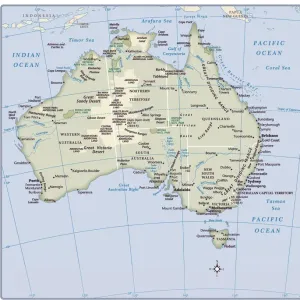
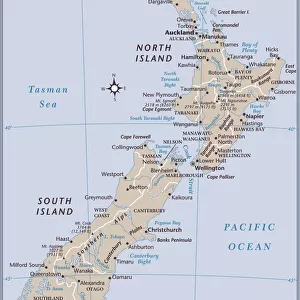
Map / Australia / Nz 1862
Map of Australia and New Zealand
Mary Evans Picture Library makes available wonderful images created for people to enjoy over the centuries
Media ID 608857
© Mary Evans Picture Library 2015 - https://copyrighthub.org/s0/hub1/creation/maryevans/MaryEvansPictureID/10114191
17"x15" (43x38cm) Premium Frame
FSC real wood frame with double mounted 10x8 print. Double mounted with white conservation mountboard. Frame moulding comprises stained composite natural wood veneers (Finger Jointed Pine) 39mm wide by 21mm thick. Archival quality Fujifilm CA photo paper mounted onto 1mm card. Overall outside dimensions are 17x15 inches (431x381mm). Rear features Framing tape to cover staples, 50mm Hanger plate, cork bumpers. Glazed with durable thick 2mm Acrylic to provide a virtually unbreakable glass-like finish. Acrylic Glass is far safer, more flexible and much lighter than typical mineral glass. Moreover, its higher translucency makes it a perfect carrier for photo prints. Acrylic allows a little more light to penetrate the surface than conventional glass and absorbs UV rays so that the image and the picture quality doesn't suffer under direct sunlight even after many years. Easily cleaned with a damp cloth. Please note that, to prevent the paper falling through the mount window and to prevent cropping of the original artwork, the visible print may be slightly smaller to allow the paper to be securely attached to the mount without any white edging showing and to match the aspect ratio of the original artwork.
FSC Real Wood Frame and Double Mounted with White Conservation Mountboard - Professionally Made and Ready to Hang
Estimated Image Size (if not cropped) is 24.4cm x 19.5cm (9.6" x 7.7")
Estimated Product Size is 43.1cm x 38.1cm (17" x 15")
These are individually made so all sizes are approximate
Artwork printed orientated as per the preview above, with landscape (horizontal) orientation to match the source image.
FEATURES IN THESE COLLECTIONS
> Maps and Charts
> Early Maps
> Maps and Charts
> Related Images
> Oceania
> Australia
> Related Images
> Oceania
> New Zealand
> Maps
> Oceania
> New Zealand
> Related Images
EDITORS COMMENTS
This stunning print captures a piece of history with the Map of Australia and New Zealand from 1862. The intricate details on this map showcase the geographical features, cities, and territories of both countries during that time period. It is fascinating to see how these lands were divided and labeled over a century ago.
The Map of Australia and New Zealand serves as a reminder of the rich history and exploration that shaped these nations. From the vast deserts of Australia to the lush landscapes of New Zealand, this map provides a glimpse into the diverse environments that make up these regions.
As we study this historical map, we can appreciate the advancements in cartography and navigation that allowed for such detailed representations to be created. It is truly a work of art that tells a story of discovery and colonization in the southern hemisphere.
Whether you have an interest in geography, history, or simply enjoy admiring antique maps, this print is sure to captivate your imagination. Display it proudly in your home or office as a conversation piece that sparks curiosity about the past.
MADE IN THE UK
Safe Shipping with 30 Day Money Back Guarantee
FREE PERSONALISATION*
We are proud to offer a range of customisation features including Personalised Captions, Color Filters and Picture Zoom Tools
SECURE PAYMENTS
We happily accept a wide range of payment options so you can pay for the things you need in the way that is most convenient for you
* Options may vary by product and licensing agreement. Zoomed Pictures can be adjusted in the Basket.