Premium Framed Print > Europe > United Kingdom > England > London > Transport > Underground
Premium Framed Print : If London flooded tomorrow, what would you do?


![]()
Framed Photos from Mary Evans Picture Library
If London flooded tomorrow, what would you do?
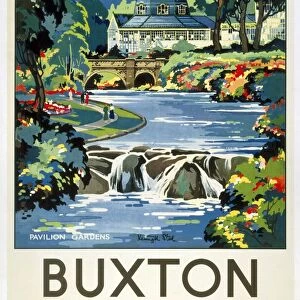
Text with map of London, showing Flood Risk Area, and underground and railway lines. If London flooded tomorrow, what would you do? This is what you must do if you live work or travel in the Flood Risk Area. Designed and prduced by Stuart Advertising Agency Ltd Printed by G and B Arts Date: 1980
Mary Evans Picture Library makes available wonderful images created for people to enjoy over the centuries
Media ID 19152196
© Mary Evans Picture Library 2015
1980 Area Flood Flooded Lines Risk This Tomorrow Underground
23"x19" (58x48cm) Premium Frame
FSC real wood frame with double mounted 16x12 print. Double mounted with white conservation mountboard. Frame moulding comprises stained composite natural wood veneers (Finger Jointed Pine) 39mm wide by 21mm thick. Archival quality Fujifilm CA photo paper mounted onto 1mm card. Overall outside dimensions are 23x19 inches (584x482mm). Rear features Framing tape to cover staples, 50mm Hanger plate, cork bumpers. Glazed with durable thick 2mm Acrylic to provide a virtually unbreakable glass-like finish. Acrylic Glass is far safer, more flexible and much lighter than typical mineral glass. Moreover, its higher translucency makes it a perfect carrier for photo prints. Acrylic allows a little more light to penetrate the surface than conventional glass and absorbs UV rays so that the image and the picture quality doesn't suffer under direct sunlight even after many years. Easily cleaned with a damp cloth. Please note that, to prevent the paper falling through the mount window and to prevent cropping of the original artwork, the visible print may be slightly smaller to allow the paper to be securely attached to the mount without any white edging showing and to match the aspect ratio of the original artwork.
FSC Real Wood Frame and Double Mounted with White Conservation Mountboard - Professionally Made and Ready to Hang
Estimated Image Size (if not cropped) is 26.5cm x 39.6cm (10.4" x 15.6")
Estimated Product Size is 48.2cm x 58.4cm (19" x 23")
These are individually made so all sizes are approximate
Artwork printed orientated as per the preview above, with portrait (vertical) orientation to match the source image.
FEATURES IN THESE COLLECTIONS
> Europe
> United Kingdom
> England
> London
> Related Images
> Europe
> United Kingdom
> England
> London
> Transport
> Underground
> Maps and Charts
> Related Images
> Popular Themes
> Railway Posters
EDITORS COMMENTS
1. "Preparing for the Unforeseen: A 1980s Guide to Surviving a Flood in London If London flooded tomorrow, what would you do? This question was a pressing concern for residents, workers, and commuters in the Flood Risk Area of the city in the late 1970s and early 1980s. The map before you, produced by an unknown advertising agency and printed by G and B Arts in 1980, outlines the areas most susceptible to flooding, as well as the crucial underground and railway lines that crisscross the city. The Flood Risk Area, marked in red on the map, encompasses many parts of central and eastern London, including the Southwark, Tower Hamlets, and Wandsworth boroughs. The Thames River, which flows through the heart of the city, poses the greatest risk, but heavy rainfall and storm surges can also cause flooding in other parts of the metropolis. In the event of a flood, the map advises several courses of action. First and foremost, residents and workers in the Flood Risk Area are urged to heed evacuation orders issued by local authorities. If evacuation is not possible, they are encouraged to move to the upper floors of their buildings and stay there, away from windows and doors. For those who rely on public transportation, the map provides alternative routes using the underground and railway lines that are least likely to be affected by flooding. It is essential to check with transport authorities for the latest information on service disruptions and closures before traveling. In conclusion, being prepared for a flood in London in the 1980s required careful planning and a solid understanding of the city's flood risk areas and transportation networks. This map, produced by an unknown advertising agency and printed by G and B Arts, serves as a testament to the importance of being informed and vigilant in the face of natural disasters.
MADE IN THE UK
Safe Shipping with 30 Day Money Back Guarantee
FREE PERSONALISATION*
We are proud to offer a range of customisation features including Personalised Captions, Color Filters and Picture Zoom Tools
SECURE PAYMENTS
We happily accept a wide range of payment options so you can pay for the things you need in the way that is most convenient for you
* Options may vary by product and licensing agreement. Zoomed Pictures can be adjusted in the Basket.