Canvas Print > Europe > United Kingdom > England > London > Transport > Underground
Canvas Print : If London flooded tomorrow, what would you do?


![]()
Canvas Prints from Mary Evans Picture Library
If London flooded tomorrow, what would you do?
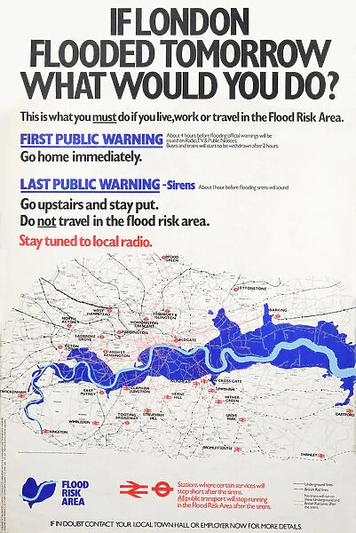
Text with map of London, showing Flood Risk Area, and underground and railway lines. If London flooded tomorrow, what would you do? This is what you must do if you live work or travel in the Flood Risk Area. Designed and prduced by Stuart Advertising Agency Ltd Printed by G and B Arts Date: 1980
Mary Evans Picture Library makes available wonderful images created for people to enjoy over the centuries
Media ID 19152196
© Mary Evans Picture Library 2015
1980 Area Flood Flooded Lines Risk This Tomorrow Underground
21"x14" (53x35cm) Canvas Print
Prepare for the unexpected with our captivating Canvas Print from Media Storehouse, featuring the thought-provoking image "If London Flooded Tomorrow, What Would You Do?" by Rights Managed from Mary Evans Prints Online. This evocative artwork brings to life the vibrant city of London, overlaid with a map highlighting flood risk areas and essential transport networks of the underground and railway lines. Hang this conversation-starting masterpiece in your home or office as a reminder to be prepared for any eventuality. Its high-quality canvas material and vibrant color reproduction ensure a stunning addition to your space, while the protective coating guarantees durability and longevity. Order yours now and spark intrigue and inspiration in those around you.
Ready to hang Premium Gloss Canvas Print. Our archival quality canvas prints are made from Polyester and Cotton mix and stretched over a 1.25" (32mm) kiln dried knot free wood stretcher bar. Packaged in a plastic bag and secured to a cardboard insert for transit.
Canvas Prints add colour, depth and texture to any space. Professionally Stretched Canvas over a hidden Wooden Box Frame and Ready to Hang
Estimated Product Size is 35.6cm x 53.3cm (14" x 21")
These are individually made so all sizes are approximate
Artwork printed orientated as per the preview above, with portrait (vertical) orientation to match the source image.
FEATURES IN THESE COLLECTIONS
> Europe
> United Kingdom
> England
> London
> Related Images
> Europe
> United Kingdom
> England
> London
> Transport
> Underground
> Maps and Charts
> Related Images
> Popular Themes
> Railway Posters
EDITORS COMMENTS
1. "Preparing for the Unforeseen: A 1980s Guide to Surviving a Flood in London If London flooded tomorrow, what would you do? This question was a pressing concern for residents, workers, and commuters in the Flood Risk Area of the city in the late 1970s and early 1980s. The map before you, produced by an unknown advertising agency and printed by G and B Arts in 1980, outlines the areas most susceptible to flooding, as well as the crucial underground and railway lines that crisscross the city. The Flood Risk Area, marked in red on the map, encompasses many parts of central and eastern London, including the Southwark, Tower Hamlets, and Wandsworth boroughs. The Thames River, which flows through the heart of the city, poses the greatest risk, but heavy rainfall and storm surges can also cause flooding in other parts of the metropolis. In the event of a flood, the map advises several courses of action. First and foremost, residents and workers in the Flood Risk Area are urged to heed evacuation orders issued by local authorities. If evacuation is not possible, they are encouraged to move to the upper floors of their buildings and stay there, away from windows and doors. For those who rely on public transportation, the map provides alternative routes using the underground and railway lines that are least likely to be affected by flooding. It is essential to check with transport authorities for the latest information on service disruptions and closures before traveling. In conclusion, being prepared for a flood in London in the 1980s required careful planning and a solid understanding of the city's flood risk areas and transportation networks. This map, produced by an unknown advertising agency and printed by G and B Arts, serves as a testament to the importance of being informed and vigilant in the face of natural disasters.
MADE IN THE UK
Safe Shipping with 30 Day Money Back Guarantee
FREE PERSONALISATION*
We are proud to offer a range of customisation features including Personalised Captions, Color Filters and Picture Zoom Tools
SECURE PAYMENTS
We happily accept a wide range of payment options so you can pay for the things you need in the way that is most convenient for you
* Options may vary by product and licensing agreement. Zoomed Pictures can be adjusted in the Basket.