Premium Framed Print > Maps and Charts > Related Images
Premium Framed Print : Cityscape Map of York 2017


![]()
Framed Photos from MapSeeker
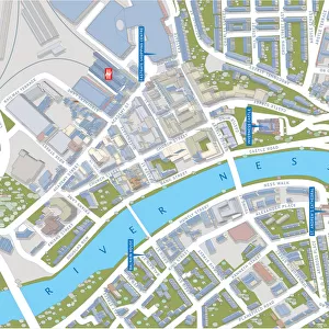
Cityscape Map of York 2017
Cityscape Map of York
Welcome to the Mapseeker Image library and enter an historic gateway to one of the largest on-line collections of Historic Maps, Nostalgic Views, Vista's and Panorama's from a World gone by.
Media ID 20354115
© Mapseeker Publishing Ltd / Richard Bowring
23"x19" (58x48cm) Premium Frame
FSC real wood frame with double mounted 16x12 print. Double mounted with white conservation mountboard. Frame moulding comprises stained composite natural wood veneers (Finger Jointed Pine) 39mm wide by 21mm thick. Archival quality Fujifilm CA photo paper mounted onto 1mm card. Overall outside dimensions are 23x19 inches (584x482mm). Rear features Framing tape to cover staples, 50mm Hanger plate, cork bumpers. Glazed with durable thick 2mm Acrylic to provide a virtually unbreakable glass-like finish. Acrylic Glass is far safer, more flexible and much lighter than typical mineral glass. Moreover, its higher translucency makes it a perfect carrier for photo prints. Acrylic allows a little more light to penetrate the surface than conventional glass and absorbs UV rays so that the image and the picture quality doesn't suffer under direct sunlight even after many years. Easily cleaned with a damp cloth. Please note that, to prevent the paper falling through the mount window and to prevent cropping of the original artwork, the visible print may be slightly smaller to allow the paper to be securely attached to the mount without any white edging showing and to match the aspect ratio of the original artwork.
FSC Real Wood Frame and Double Mounted with White Conservation Mountboard - Professionally Made and Ready to Hang
Estimated Image Size (if not cropped) is 39.6cm x 26.4cm (15.6" x 10.4")
Estimated Product Size is 58.4cm x 48.2cm (23" x 19")
These are individually made so all sizes are approximate
Artwork printed orientated as per the preview above, with landscape (horizontal) orientation to match the source image.
EDITORS COMMENTS
This stunning print captures the essence of York, a city steeped in history and brimming with architectural wonders. The Cityscape Map of York 2017 is an artistic masterpiece that beautifully showcases the intricate layout of this enchanting English city. Created by renowned artist Richard Bowring, this map is more than just a navigational tool; it is a work of art that celebrates the unique charm and character of York. As you gaze upon this image, your eyes are immediately drawn to the magnificent medieval structures that dominate the skyline. From the iconic York Minster, with its towering spires reaching towards the heavens, to the ancient city walls that encircle and protect centuries-old secrets within their stone embrace – every detail has been meticulously captured. The intertwining streets and alleyways invite exploration as they wind through historic neighborhoods such as The Shambles or lead you to hidden gems like Clifford's Tower or Micklegate Bar. Each street corner holds stories waiting to be discovered; tales from Roman times, Viking invasions, and Tudor reigns whisper through every brick. Whether you have fond memories of wandering these cobblestone streets or dream of one day experiencing their magic for yourself, this Cityscape Map of York serves as a timeless reminder of a place where past meets present in perfect harmony. Let it transport you into an immersive world where history comes alive amidst charming tea rooms, bustling markets, and picturesque gardens - all awaiting your next adventure in beautiful York City.
MADE IN THE UK
Safe Shipping with 30 Day Money Back Guarantee
FREE PERSONALISATION*
We are proud to offer a range of customisation features including Personalised Captions, Color Filters and Picture Zoom Tools
SECURE PAYMENTS
We happily accept a wide range of payment options so you can pay for the things you need in the way that is most convenient for you
* Options may vary by product and licensing agreement. Zoomed Pictures can be adjusted in the Basket.