Fine Art Print > Maps and Charts > Related Images
Fine Art Print : Cityscape Map of York 2017


![]()
Fine Art Prints from MapSeeker
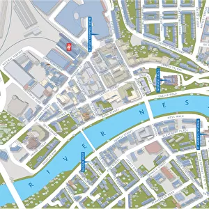
Cityscape Map of York 2017
Cityscape Map of York
Welcome to the Mapseeker Image library and enter an historic gateway to one of the largest on-line collections of Historic Maps, Nostalgic Views, Vista's and Panorama's from a World gone by.
Media ID 20354115
© Mapseeker Publishing Ltd / Richard Bowring
A2 (42x59cm) Fine Art Print
Discover the timeless beauty of York with our exquisite Cityscape Map of York 2017 print from Media Storehouse's Fine Art Prints collection. This stunning representation of the historic city, produced by MapSeeker, invites you to explore the intricate details of its iconic landmarks and winding streets. Bring the charm of York right into your home or office with this beautifully crafted, museum-quality print. A perfect addition to any space, this fine art print is sure to inspire a sense of wonder and appreciation for the rich history and culture of this remarkable city.
Our Fine Art Prints are printed on 100% acid free, PH neutral paper with archival properties. This printing method is used by museums and art collections to exhibit photographs and art reproductions. Hahnemühle certified studio for digital fine art printing. Printed on 308gsm Photo Rag Paper.
Our fine art prints are high-quality prints made using a paper called Photo Rag. This 100% cotton rag fibre paper is known for its exceptional image sharpness, rich colors, and high level of detail, making it a popular choice for professional photographers and artists. Photo rag paper is our clear recommendation for a fine art paper print. If you can afford to spend more on a higher quality paper, then Photo Rag is our clear recommendation for a fine art paper print.
Estimated Image Size (if not cropped) is 59.4cm x 39.6cm (23.4" x 15.6")
Estimated Product Size is 59.4cm x 42cm (23.4" x 16.5")
These are individually made so all sizes are approximate
Artwork printed orientated as per the preview above, with landscape (horizontal) orientation to match the source image.
EDITORS COMMENTS
This stunning print captures the essence of York, a city steeped in history and brimming with architectural wonders. The Cityscape Map of York 2017 is an artistic masterpiece that beautifully showcases the intricate layout of this enchanting English city. Created by renowned artist Richard Bowring, this map is more than just a navigational tool; it is a work of art that celebrates the unique charm and character of York. As you gaze upon this image, your eyes are immediately drawn to the magnificent medieval structures that dominate the skyline. From the iconic York Minster, with its towering spires reaching towards the heavens, to the ancient city walls that encircle and protect centuries-old secrets within their stone embrace – every detail has been meticulously captured. The intertwining streets and alleyways invite exploration as they wind through historic neighborhoods such as The Shambles or lead you to hidden gems like Clifford's Tower or Micklegate Bar. Each street corner holds stories waiting to be discovered; tales from Roman times, Viking invasions, and Tudor reigns whisper through every brick. Whether you have fond memories of wandering these cobblestone streets or dream of one day experiencing their magic for yourself, this Cityscape Map of York serves as a timeless reminder of a place where past meets present in perfect harmony. Let it transport you into an immersive world where history comes alive amidst charming tea rooms, bustling markets, and picturesque gardens - all awaiting your next adventure in beautiful York City.
MADE IN THE UK
Safe Shipping with 30 Day Money Back Guarantee
FREE PERSONALISATION*
We are proud to offer a range of customisation features including Personalised Captions, Color Filters and Picture Zoom Tools
SECURE PAYMENTS
We happily accept a wide range of payment options so you can pay for the things you need in the way that is most convenient for you
* Options may vary by product and licensing agreement. Zoomed Pictures can be adjusted in the Basket.