Premium Framed Print > Europe > United Kingdom > Scotland > Highlands > Inverness
Premium Framed Print : Cityscape Map of Inverness 2011


![]()
Framed Photos from MapSeeker
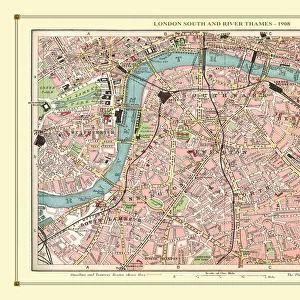
Cityscape Map of Inverness 2011
Cityscape Map of Inverness
Welcome to the Mapseeker Image library and enter an historic gateway to one of the largest on-line collections of Historic Maps, Nostalgic Views, Vista's and Panorama's from a World gone by.
Media ID 20354117
© Mapseeker Publishing Ltd / Richard Bowring
23"x19" (58x48cm) Premium Frame
FSC real wood frame with double mounted 16x12 print. Double mounted with white conservation mountboard. Frame moulding comprises stained composite natural wood veneers (Finger Jointed Pine) 39mm wide by 21mm thick. Archival quality Fujifilm CA photo paper mounted onto 1mm card. Overall outside dimensions are 23x19 inches (584x482mm). Rear features Framing tape to cover staples, 50mm Hanger plate, cork bumpers. Glazed with durable thick 2mm Acrylic to provide a virtually unbreakable glass-like finish. Acrylic Glass is far safer, more flexible and much lighter than typical mineral glass. Moreover, its higher translucency makes it a perfect carrier for photo prints. Acrylic allows a little more light to penetrate the surface than conventional glass and absorbs UV rays so that the image and the picture quality doesn't suffer under direct sunlight even after many years. Easily cleaned with a damp cloth. Please note that, to prevent the paper falling through the mount window and to prevent cropping of the original artwork, the visible print may be slightly smaller to allow the paper to be securely attached to the mount without any white edging showing and to match the aspect ratio of the original artwork.
FSC Real Wood Frame and Double Mounted with White Conservation Mountboard - Professionally Made and Ready to Hang
Estimated Image Size (if not cropped) is 39.6cm x 26.4cm (15.6" x 10.4")
Estimated Product Size is 58.4cm x 48.2cm (23" x 19")
These are individually made so all sizes are approximate
Artwork printed orientated as per the preview above, with landscape (horizontal) orientation to match the source image.
FEATURES IN THESE COLLECTIONS
> Europe
> United Kingdom
> Scotland
> Highlands
> Inverness
> Maps and Charts
> Related Images
EDITORS COMMENTS
This print showcases the intricate beauty of Inverness, Scotland's enchanting cityscape. Crafted by the talented artist Steve Bowring in 2011, this detailed map offers a unique perspective on the urban landscape that will surely captivate any viewer. The Cityscape Map of Inverness takes us on a visual journey through this historic city, renowned for its rich cultural heritage and stunning natural surroundings. From the iconic River Ness flowing gracefully through its heart to the majestic Inverness Castle perched proudly atop a hill, every landmark is meticulously depicted with precision and artistry. Bowring's masterful use of colors and textures brings life to each building, street, and park within this remarkable artwork. The vibrant hues beautifully reflect both day and night scenes, capturing the essence of Inverness' bustling energy during daylight hours while also showcasing its serene charm under moonlit skies. Whether you are an admirer of cartography or simply have an affinity for beautiful cityscapes, this print is sure to be a cherished addition to your collection. Its artistic allure effortlessly transports you into the heart of Inverness as you explore its winding streets and hidden corners from afar. As we gaze upon this mesmerizing piece by Steve Bowring, we are reminded not only of his exceptional talent but also of our own connection to places that hold special meaning in our lives – like Inverness does for so many fortunate souls who have had the pleasure of experiencing its magic firsthand.
MADE IN THE UK
Safe Shipping with 30 Day Money Back Guarantee
FREE PERSONALISATION*
We are proud to offer a range of customisation features including Personalised Captions, Color Filters and Picture Zoom Tools
SECURE PAYMENTS
We happily accept a wide range of payment options so you can pay for the things you need in the way that is most convenient for you
* Options may vary by product and licensing agreement. Zoomed Pictures can be adjusted in the Basket.