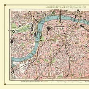
Canvas Print > Europe > United Kingdom > Scotland > Highlands > Inverness
Canvas Print : Cityscape Map of Inverness 2011


![]()
Canvas Prints from MapSeeker
Cityscape Map of Inverness 2011
Cityscape Map of Inverness
Welcome to the Mapseeker Image library and enter an historic gateway to one of the largest on-line collections of Historic Maps, Nostalgic Views, Vista's and Panorama's from a World gone by.
Media ID 20354117
© Mapseeker Publishing Ltd / Richard Bowring
21"x14" (53x35cm) Canvas Print
Bring the beauty of Inverness into your home with our exquisite Canvas Prints from Media Storehouse. This particular print features a stunning Cityscape Map of Inverness, as captured by MapSeeker in 2011. The intricate details of the map are beautifully rendered in vibrant colors on high-quality canvas, creating a stunning work of art that is sure to be a conversation starter. Each print is expertly crafted using premium materials and techniques to ensure a long-lasting, museum-quality finish. Add a touch of Scottish charm to your living space with this unique and captivating Cityscape Map of Inverness Canvas Print from Media Storehouse.
Ready to hang Premium Gloss Canvas Print. Our archival quality canvas prints are made from Polyester and Cotton mix and stretched over a 1.25" (32mm) kiln dried knot free wood stretcher bar. Packaged in a plastic bag and secured to a cardboard insert for transit.
Canvas Prints add colour, depth and texture to any space. Professionally Stretched Canvas over a hidden Wooden Box Frame and Ready to Hang
Estimated Product Size is 53.3cm x 35.6cm (21" x 14")
These are individually made so all sizes are approximate
Artwork printed orientated as per the preview above, with landscape (horizontal) orientation to match the source image.
FEATURES IN THESE COLLECTIONS
> Europe
> United Kingdom
> Scotland
> Highlands
> Inverness
> Maps and Charts
> Related Images
EDITORS COMMENTS
This print showcases the intricate beauty of Inverness, Scotland's enchanting cityscape. Crafted by the talented artist Steve Bowring in 2011, this detailed map offers a unique perspective on the urban landscape that will surely captivate any viewer. The Cityscape Map of Inverness takes us on a visual journey through this historic city, renowned for its rich cultural heritage and stunning natural surroundings. From the iconic River Ness flowing gracefully through its heart to the majestic Inverness Castle perched proudly atop a hill, every landmark is meticulously depicted with precision and artistry. Bowring's masterful use of colors and textures brings life to each building, street, and park within this remarkable artwork. The vibrant hues beautifully reflect both day and night scenes, capturing the essence of Inverness' bustling energy during daylight hours while also showcasing its serene charm under moonlit skies. Whether you are an admirer of cartography or simply have an affinity for beautiful cityscapes, this print is sure to be a cherished addition to your collection. Its artistic allure effortlessly transports you into the heart of Inverness as you explore its winding streets and hidden corners from afar. As we gaze upon this mesmerizing piece by Steve Bowring, we are reminded not only of his exceptional talent but also of our own connection to places that hold special meaning in our lives – like Inverness does for so many fortunate souls who have had the pleasure of experiencing its magic firsthand.
MADE IN THE UK
Safe Shipping with 30 Day Money Back Guarantee
FREE PERSONALISATION*
We are proud to offer a range of customisation features including Personalised Captions, Color Filters and Picture Zoom Tools
SECURE PAYMENTS
We happily accept a wide range of payment options so you can pay for the things you need in the way that is most convenient for you
* Options may vary by product and licensing agreement. Zoomed Pictures can be adjusted in the Basket.