Premium Framed Print > Arts > Photorealistic artworks > Detailed art pieces > Masterful detailing in art
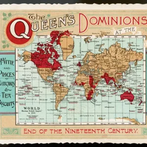
Premium Framed Print : Map of The British Empire by Fullarton & Co 1850


![]()
Framed Photos from MapSeeker
Map of The British Empire by Fullarton & Co 1850
Fine reproduction of the attractive World Map showing the British Empire. Mapmaker John Bartholomew and publishers Fullarton were then the first to use red or pink to indicate British possessions around the world, a feature which became common to most maps for the next 100 years. In this map, which dates back to the 1850AEs states in notes at the top of the map oThe British Possessions are engraved in a bolder character and coloured Redo. The map is also framed by idealized images of friendly encounters between British colonists and indigenous inhabitants in four different parts of the Globe: Australia, North America, British Asia, East Inidican islands and the Cape Colony in Southern Africa. It is highly detailed and decorative and it appeared in FullartonAEs Royal Illustrated Atlas which was first published in 1864 after being issued in 27 parts from 1854-62. The tables shown include the size and population of the British possessions at the time of publication
Welcome to the Mapseeker Image library and enter an historic gateway to one of the largest on-line collections of Historic Maps, Nostalgic Views, Vista's and Panorama's from a World gone by.
Media ID 20347041
Map Of The World Old Map Of The World The World World Map British Empire
23"x19" (58x48cm) Premium Frame
FSC real wood frame with double mounted 16x12 print. Double mounted with white conservation mountboard. Frame moulding comprises stained composite natural wood veneers (Finger Jointed Pine) 39mm wide by 21mm thick. Archival quality Fujifilm CA photo paper mounted onto 1mm card. Overall outside dimensions are 23x19 inches (584x482mm). Rear features Framing tape to cover staples, 50mm Hanger plate, cork bumpers. Glazed with durable thick 2mm Acrylic to provide a virtually unbreakable glass-like finish. Acrylic Glass is far safer, more flexible and much lighter than typical mineral glass. Moreover, its higher translucency makes it a perfect carrier for photo prints. Acrylic allows a little more light to penetrate the surface than conventional glass and absorbs UV rays so that the image and the picture quality doesn't suffer under direct sunlight even after many years. Easily cleaned with a damp cloth. Please note that, to prevent the paper falling through the mount window and to prevent cropping of the original artwork, the visible print may be slightly smaller to allow the paper to be securely attached to the mount without any white edging showing and to match the aspect ratio of the original artwork.
FSC Real Wood Frame and Double Mounted with White Conservation Mountboard - Professionally Made and Ready to Hang
Estimated Image Size (if not cropped) is 39.6cm x 26.4cm (15.6" x 10.4")
Estimated Product Size is 58.4cm x 48.2cm (23" x 19")
These are individually made so all sizes are approximate
Artwork printed orientated as per the preview above, with landscape (horizontal) orientation to match the source image.
FEATURES IN THESE COLLECTIONS
> Arts
> Photorealistic artworks
> Detailed art pieces
> Masterful detailing in art
> Asia
> East Timor
> Maps
> Asia
> East Timor
> Related Images
> Maps and Charts
> British Empire Maps
> Maps and Charts
> Related Images
> Maps and Charts
> World
EDITORS COMMENTS
This print showcases a fine reproduction of the Map of The British Empire by Fullarton & Co from 1850. Renowned mapmaker John Bartholomew and publishers Fullarton were pioneers in their use of red or pink to highlight British possessions across the globe, a convention that would endure for the next century. This particular map, dating back to the 1850s, proudly declares at its summit that "The British Possessions are engraved in a bolder character and coloured Red". What sets this map apart is its exquisite attention to detail and decorative elements. Framing the edges are idyllic depictions of harmonious encounters between British colonists and indigenous inhabitants in various regions: Australia, North America, British Asia, East Indian islands, and the Cape Colony in Southern Africa. These images serve as reminders of Britain's global influence during this era. Originally featured in Fullarton's Royal Illustrated Atlas published in 1864 (after being issued in parts from 1854-62), this map not only provides geographical information but also includes tables presenting the size and population of each British possession at that time. With its historical significance as one of the earliest maps utilizing color-coded indicators for colonial territories and its striking visual appeal through intricate illustrations, this print offers an intriguing glimpse into an era when Britannia ruled over vast expanses around the world.
MADE IN THE UK
Safe Shipping with 30 Day Money Back Guarantee
FREE PERSONALISATION*
We are proud to offer a range of customisation features including Personalised Captions, Color Filters and Picture Zoom Tools
SECURE PAYMENTS
We happily accept a wide range of payment options so you can pay for the things you need in the way that is most convenient for you
* Options may vary by product and licensing agreement. Zoomed Pictures can be adjusted in the Basket.