Premium Framed Print > Maps and Charts > Early Maps
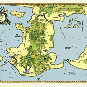
Premium Framed Print : Early Coastal Survey Map of the Isle of Wight, Spithead and Portsmouth Harbour 1794


![]()
Framed Photos from MapSeeker
Early Coastal Survey Map of the Isle of Wight, Spithead and Portsmouth Harbour 1794
This is a colour reproduction of the attractive coastal chart of the Isle of Wight, Spithead and Portsmouth Harbour originally published in 1794 by Jos Avery
Welcome to the Mapseeker Image library and enter an historic gateway to one of the largest on-line collections of Historic Maps, Nostalgic Views, Vista's and Panorama's from a World gone by.
Media ID 20347509
Isle Of Wight Portsmouth Harbour Spithead
23"x19" (58x48cm) Premium Frame
FSC real wood frame with double mounted 16x12 print. Double mounted with white conservation mountboard. Frame moulding comprises stained composite natural wood veneers (Finger Jointed Pine) 39mm wide by 21mm thick. Archival quality Fujifilm CA photo paper mounted onto 1mm card. Overall outside dimensions are 23x19 inches (584x482mm). Rear features Framing tape to cover staples, 50mm Hanger plate, cork bumpers. Glazed with durable thick 2mm Acrylic to provide a virtually unbreakable glass-like finish. Acrylic Glass is far safer, more flexible and much lighter than typical mineral glass. Moreover, its higher translucency makes it a perfect carrier for photo prints. Acrylic allows a little more light to penetrate the surface than conventional glass and absorbs UV rays so that the image and the picture quality doesn't suffer under direct sunlight even after many years. Easily cleaned with a damp cloth. Please note that, to prevent the paper falling through the mount window and to prevent cropping of the original artwork, the visible print may be slightly smaller to allow the paper to be securely attached to the mount without any white edging showing and to match the aspect ratio of the original artwork.
FSC Real Wood Frame and Double Mounted with White Conservation Mountboard - Professionally Made and Ready to Hang
Estimated Image Size (if not cropped) is 39.6cm x 26.4cm (15.6" x 10.4")
Estimated Product Size is 58.4cm x 48.2cm (23" x 19")
These are individually made so all sizes are approximate
Artwork printed orientated as per the preview above, with landscape (horizontal) orientation to match the source image.
FEATURES IN THESE COLLECTIONS
> MapSeeker
> Maps from the British Isles
> British Coastal Surveys PORTFOLIO
> MapSeeker
> Maps from the British Isles
> Islands around Britain PORTFOLIO
> Maps and Charts
> Early Maps
> Maps and Charts
> Related Images
EDITORS COMMENTS
This print showcases an exquisite colour reproduction of the Early Coastal Survey Map of the Isle of Wight, Spithead, and Portsmouth Harbour. Originally published in 1794 by the talented cartographer Jos Avery, this map offers a fascinating glimpse into the coastal landscape of that era. The intricate details depicted on this chart provide a valuable historical record of these renowned British locations. The Isle of Wight, with its stunning coastline and diverse topography, is beautifully illustrated with precision and artistry. From sandy beaches to rocky cliffs, every contour is meticulously captured. Spithead, known for its strategic importance as a natural anchorage for naval vessels during that time period, is also prominently featured on this map. Its deep waters and sheltered bay are clearly marked, serving as a reminder of Britain's maritime heritage. Portsmouth Harbour takes center stage in this visual masterpiece. As one of England's most significant naval bases throughout history, it played a crucial role in protecting the nation's shores. This survey map provides invaluable insights into its layout during the late 18th century. Whether you're an avid historian or simply appreciate fine craftsmanship, this print will undoubtedly captivate your imagination. It serves as both an educational tool and a beautiful piece of art that transports you back to an era when coastal surveys were essential for navigation and defense purposes.
MADE IN THE UK
Safe Shipping with 30 Day Money Back Guarantee
FREE PERSONALISATION*
We are proud to offer a range of customisation features including Personalised Captions, Color Filters and Picture Zoom Tools
SECURE PAYMENTS
We happily accept a wide range of payment options so you can pay for the things you need in the way that is most convenient for you
* Options may vary by product and licensing agreement. Zoomed Pictures can be adjusted in the Basket.