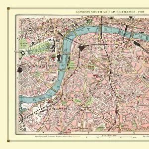
Framed Print > Maps and Charts > Early Maps
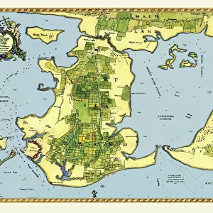
Framed Print : Early Coastal Survey Map of the Isle of Wight, Spithead and Portsmouth Harbour 1794


![]()
Framed Photos from MapSeeker
Early Coastal Survey Map of the Isle of Wight, Spithead and Portsmouth Harbour 1794
This is a colour reproduction of the attractive coastal chart of the Isle of Wight, Spithead and Portsmouth Harbour originally published in 1794 by Jos Avery
Welcome to the Mapseeker Image library and enter an historic gateway to one of the largest on-line collections of Historic Maps, Nostalgic Views, Vista's and Panorama's from a World gone by.
Media ID 20347509
Isle Of Wight Portsmouth Harbour Spithead
22"x18" (58x48cm) Modern Frame
Step back in time with our captivating Framed Prints from the Media Storehouse collection. This exquisite piece showcases an Early Coastal Survey Map of the Isle of Wight, Spithead and Portsmouth Harbour, originally published in 1794 by Jos Avery. The vibrant colours and intricate details of this MapSeeker reproduction bring the history of maritime cartography to life. Hang this beautiful framed print in your home or office to add a touch of timeless charm and nautical allure to any space.
Wood effect frame, card mounted, 16x12 archival quality photo print. Overall outside dimensions 22x18 inches (58x48cm). Environmentally and ozone friendly, 40mm wide x 15mm Polycore® moulding has the look of real wood, is durable and light and easy to hang. Biodegradable and made with non-chlorinated gases (no toxic fumes) it is efficient; producing 100 tons of polystyrene can save 300 tons of trees! Prints are glazed with lightweight, shatterproof, optical clarity acrylic (providing the same general protection from the environment as glass). The back is stapled hardboard with a sawtooth hanger attached. Note: To minimise original artwork cropping, for optimum layout, and to ensure print is secure, the visible print may be marginally smaller
Contemporary Framed and Mounted Prints - Professionally Made and Ready to Hang
Estimated Image Size (if not cropped) is 39.6cm x 26.4cm (15.6" x 10.4")
Estimated Product Size is 57.9cm x 47.8cm (22.8" x 18.8")
These are individually made so all sizes are approximate
Artwork printed orientated as per the preview above, with landscape (horizontal) orientation to match the source image.
FEATURES IN THESE COLLECTIONS
> Maps and Charts
> Early Maps
> Maps and Charts
> Related Images
> MapSeeker
> Maps from the British Isles
> British Coastal Surveys PORTFOLIO
> MapSeeker
> Maps from the British Isles
> Islands around Britain PORTFOLIO
EDITORS COMMENTS
This print showcases an exquisite colour reproduction of the Early Coastal Survey Map of the Isle of Wight, Spithead, and Portsmouth Harbour. Originally published in 1794 by the talented cartographer Jos Avery, this map offers a fascinating glimpse into the coastal landscape of that era. The intricate details depicted on this chart provide a valuable historical record of these renowned British locations. The Isle of Wight, with its stunning coastline and diverse topography, is beautifully illustrated with precision and artistry. From sandy beaches to rocky cliffs, every contour is meticulously captured. Spithead, known for its strategic importance as a natural anchorage for naval vessels during that time period, is also prominently featured on this map. Its deep waters and sheltered bay are clearly marked, serving as a reminder of Britain's maritime heritage. Portsmouth Harbour takes center stage in this visual masterpiece. As one of England's most significant naval bases throughout history, it played a crucial role in protecting the nation's shores. This survey map provides invaluable insights into its layout during the late 18th century. Whether you're an avid historian or simply appreciate fine craftsmanship, this print will undoubtedly captivate your imagination. It serves as both an educational tool and a beautiful piece of art that transports you back to an era when coastal surveys were essential for navigation and defense purposes.
MADE IN THE UK
Safe Shipping with 30 Day Money Back Guarantee
FREE PERSONALISATION*
We are proud to offer a range of customisation features including Personalised Captions, Color Filters and Picture Zoom Tools
SECURE PAYMENTS
We happily accept a wide range of payment options so you can pay for the things you need in the way that is most convenient for you
* Options may vary by product and licensing agreement. Zoomed Pictures can be adjusted in the Basket.