Premium Framed Print > Europe > United Kingdom > England > Durham > Durham
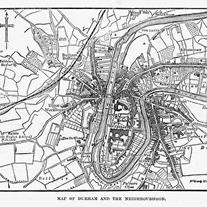
Premium Framed Print : Old Map of Durham 1898 from the Royal Atlas by Bartholomew


![]()
Framed Photos from MapSeeker
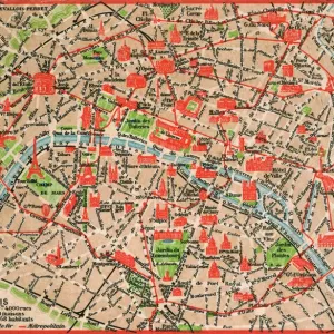
Old Map of Durham 1898 from the Royal Atlas by Bartholomew
A fine very detailed plan of the City of Durham remastered from an original contained within " The Royal Atlas of England and Wales" ; edited by J.G. Bartholomew, published by George Newnes, Limited, London
Welcome to the Mapseeker Image library and enter an historic gateway to one of the largest on-line collections of Historic Maps, Nostalgic Views, Vista's and Panorama's from a World gone by.
Media ID 20347604
Bartholomew Bartholomew Map Historic Map Old Town Plan Royal Atlas Royal Atlas Map Durham Durham City
23"x19" (58x48cm) Premium Frame
FSC real wood frame with double mounted 16x12 print. Double mounted with white conservation mountboard. Frame moulding comprises stained composite natural wood veneers (Finger Jointed Pine) 39mm wide by 21mm thick. Archival quality Fujifilm CA photo paper mounted onto 1mm card. Overall outside dimensions are 23x19 inches (584x482mm). Rear features Framing tape to cover staples, 50mm Hanger plate, cork bumpers. Glazed with durable thick 2mm Acrylic to provide a virtually unbreakable glass-like finish. Acrylic Glass is far safer, more flexible and much lighter than typical mineral glass. Moreover, its higher translucency makes it a perfect carrier for photo prints. Acrylic allows a little more light to penetrate the surface than conventional glass and absorbs UV rays so that the image and the picture quality doesn't suffer under direct sunlight even after many years. Easily cleaned with a damp cloth. Please note that, to prevent the paper falling through the mount window and to prevent cropping of the original artwork, the visible print may be slightly smaller to allow the paper to be securely attached to the mount without any white edging showing and to match the aspect ratio of the original artwork.
FSC Real Wood Frame and Double Mounted with White Conservation Mountboard - Professionally Made and Ready to Hang
Estimated Image Size (if not cropped) is 39.6cm x 26.4cm (15.6" x 10.4")
Estimated Product Size is 58.4cm x 48.2cm (23" x 19")
These are individually made so all sizes are approximate
Artwork printed orientated as per the preview above, with landscape (horizontal) orientation to match the source image.
FEATURES IN THESE COLLECTIONS
> MapSeeker
> British Town And City Plans
> English & Welsh PORTFOLIO
> Arts
> Photorealistic artworks
> Detailed art pieces
> Masterful detailing in art
> Europe
> United Kingdom
> England
> Durham
> Durham
> Europe
> United Kingdom
> England
> London
> Royalty
> Europe
> United Kingdom
> England
> Maps
> Europe
> United Kingdom
> Wales
> Maps
> Europe
> United Kingdom
> Wales
> Posters
> Maps and Charts
> Related Images
> Maps and Charts
> Wales
EDITORS COMMENTS
Step back in time with this exquisite print of the 'Old Map of Durham 1898' from the renowned Royal Atlas by Bartholomew. Immerse yourself in the rich history of Durham as you explore this fine and highly detailed plan of the city. Remastered from an original map found within 'The Royal Atlas of England and Wales, ' edited by J. G. Bartholomew, and published by George Newnes, Limited in London. This town plan offers a fascinating glimpse into Durham's past, showcasing its intricate layout and landmarks as they stood over a century ago. Every street, building, and pathway has been meticulously preserved on this historic map – a true testament to the craftsmanship that went into creating it. Whether you are a history enthusiast or simply curious about Durham's heritage, this old town plan is sure to transport you back in time. Marvel at how the city has evolved since 1898 while tracing your finger along its streets on this beautifully restored print. Perfect for framing or displaying as part of your collection, this authentic piece captures not only the essence but also the spirit of Durham's storied past. Discover why The Royal Atlas remains an invaluable resource for historians and cartography enthusiasts alike
MADE IN THE UK
Safe Shipping with 30 Day Money Back Guarantee
FREE PERSONALISATION*
We are proud to offer a range of customisation features including Personalised Captions, Color Filters and Picture Zoom Tools
SECURE PAYMENTS
We happily accept a wide range of payment options so you can pay for the things you need in the way that is most convenient for you
* Options may vary by product and licensing agreement. Zoomed Pictures can be adjusted in the Basket.