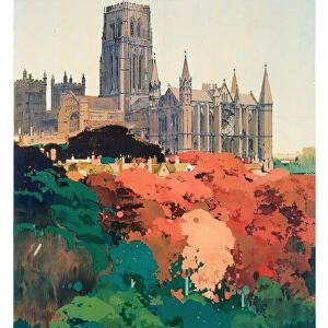
Framed Print > Europe > United Kingdom > England > Durham > Durham
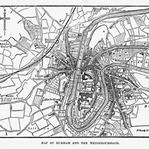
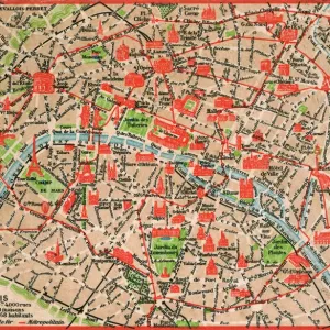
Framed Print : Old Map of Durham 1898 from the Royal Atlas by Bartholomew


![]()
Framed Photos from MapSeeker
Old Map of Durham 1898 from the Royal Atlas by Bartholomew
A fine very detailed plan of the City of Durham remastered from an original contained within " The Royal Atlas of England and Wales" ; edited by J.G. Bartholomew, published by George Newnes, Limited, London
Welcome to the Mapseeker Image library and enter an historic gateway to one of the largest on-line collections of Historic Maps, Nostalgic Views, Vista's and Panorama's from a World gone by.
Media ID 20347604
Bartholomew Bartholomew Map Historic Map Old Town Plan Royal Atlas Royal Atlas Map Durham Durham City
22"x18" (58x48cm) Modern Frame
Introducing the Media Storehouse Framed Print of the Old Map of Durham 1898, meticulously sourced from the esteemed Royal Atlas by Bartholomew. This exquisite reproduction offers a captivating glimpse into the history of Durham City with its intricate details and precise cartography. Remastered from an original contained within "The Royal Atlas of England and Wales," edited by J.G, this Old Map of Durham is a must-have for history enthusiasts and those who appreciate the beauty of antique maps. Transport yourself back in time and adorn your walls with this stunning piece of cartographic history.
Wood effect frame, card mounted, 16x12 archival quality photo print. Overall outside dimensions 22x18 inches (58x48cm). Environmentally and ozone friendly, 40mm wide x 15mm Polycore® moulding has the look of real wood, is durable and light and easy to hang. Biodegradable and made with non-chlorinated gases (no toxic fumes) it is efficient; producing 100 tons of polystyrene can save 300 tons of trees! Prints are glazed with lightweight, shatterproof, optical clarity acrylic (providing the same general protection from the environment as glass). The back is stapled hardboard with a sawtooth hanger attached. Note: To minimise original artwork cropping, for optimum layout, and to ensure print is secure, the visible print may be marginally smaller
Contemporary Framed and Mounted Prints - Professionally Made and Ready to Hang
Estimated Image Size (if not cropped) is 39.6cm x 26.4cm (15.6" x 10.4")
Estimated Product Size is 57.9cm x 47.8cm (22.8" x 18.8")
These are individually made so all sizes are approximate
Artwork printed orientated as per the preview above, with landscape (horizontal) orientation to match the source image.
FEATURES IN THESE COLLECTIONS
> Arts
> Photorealistic artworks
> Detailed art pieces
> Masterful detailing in art
> Europe
> United Kingdom
> England
> Durham
> Durham
> Europe
> United Kingdom
> England
> London
> Royalty
> Europe
> United Kingdom
> England
> Maps
> Europe
> United Kingdom
> Wales
> Maps
> Europe
> United Kingdom
> Wales
> Posters
> Maps and Charts
> Related Images
> Maps and Charts
> Wales
> MapSeeker
> British Town And City Plans
> English & Welsh PORTFOLIO
EDITORS COMMENTS
Step back in time with this exquisite print of the 'Old Map of Durham 1898' from the renowned Royal Atlas by Bartholomew. Immerse yourself in the rich history of Durham as you explore this fine and highly detailed plan of the city. Remastered from an original map found within 'The Royal Atlas of England and Wales, ' edited by J. G. Bartholomew, and published by George Newnes, Limited in London. This town plan offers a fascinating glimpse into Durham's past, showcasing its intricate layout and landmarks as they stood over a century ago. Every street, building, and pathway has been meticulously preserved on this historic map – a true testament to the craftsmanship that went into creating it. Whether you are a history enthusiast or simply curious about Durham's heritage, this old town plan is sure to transport you back in time. Marvel at how the city has evolved since 1898 while tracing your finger along its streets on this beautifully restored print. Perfect for framing or displaying as part of your collection, this authentic piece captures not only the essence but also the spirit of Durham's storied past. Discover why The Royal Atlas remains an invaluable resource for historians and cartography enthusiasts alike
MADE IN THE UK
Safe Shipping with 30 Day Money Back Guarantee
FREE PERSONALISATION*
We are proud to offer a range of customisation features including Personalised Captions, Color Filters and Picture Zoom Tools
SECURE PAYMENTS
We happily accept a wide range of payment options so you can pay for the things you need in the way that is most convenient for you
* Options may vary by product and licensing agreement. Zoomed Pictures can be adjusted in the Basket.