Premium Framed Print > Europe > United Kingdom > Wales > Maps
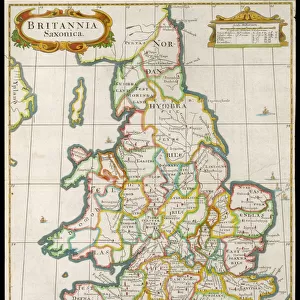
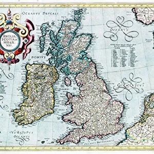
Premium Framed Print : A Topographical Dictionary of Wales, map of North and South Wales, 19th century engraving


![]()
Framed Photos from Liszt Collection
A Topographical Dictionary of Wales, map of North and South Wales, 19th century engraving
Liszt Collection of nineteenth-century engravings and images to browse and enjoy
Media ID 12806309
© Quint Lox Limited
North South Wales Topographical Dictionary Wales
17"x15" (43x38cm) Premium Frame
FSC real wood frame with double mounted 10x8 print. Double mounted with white conservation mountboard. Frame moulding comprises stained composite natural wood veneers (Finger Jointed Pine) 39mm wide by 21mm thick. Archival quality Fujifilm CA photo paper mounted onto 1mm card. Overall outside dimensions are 17x15 inches (431x381mm). Rear features Framing tape to cover staples, 50mm Hanger plate, cork bumpers. Glazed with durable thick 2mm Acrylic to provide a virtually unbreakable glass-like finish. Acrylic Glass is far safer, more flexible and much lighter than typical mineral glass. Moreover, its higher translucency makes it a perfect carrier for photo prints. Acrylic allows a little more light to penetrate the surface than conventional glass and absorbs UV rays so that the image and the picture quality doesn't suffer under direct sunlight even after many years. Easily cleaned with a damp cloth. Please note that, to prevent the paper falling through the mount window and to prevent cropping of the original artwork, the visible print may be slightly smaller to allow the paper to be securely attached to the mount without any white edging showing and to match the aspect ratio of the original artwork.
FSC Real Wood Frame and Double Mounted with White Conservation Mountboard - Professionally Made and Ready to Hang
Estimated Image Size (if not cropped) is 21.5cm x 24.4cm (8.5" x 9.6")
Estimated Product Size is 38.1cm x 43.1cm (15" x 17")
These are individually made so all sizes are approximate
Artwork printed orientated as per the preview above, with portrait (vertical) orientation to match the source image.
FEATURES IN THESE COLLECTIONS
> Europe
> United Kingdom
> Wales
> Maps
> Europe
> United Kingdom
> Wales
> Posters
> Europe
> United Kingdom
> Wales
> Related Images
> Maps and Charts
> Related Images
> Maps and Charts
> Wales
EDITORS COMMENTS
This 19th-century engraving from the Liszt Collection showcases a remarkable map of North and South Wales, extracted from "A Topographical Dictionary of Wales". A true testament to the artistry and precision of cartography during this era, this print offers a glimpse into the rich history and topography of these Welsh regions. The intricate details etched on this map provide an immersive experience for any viewer. From the rolling hills and valleys to the meandering rivers that crisscross both North and South Wales, every feature is meticulously depicted with utmost accuracy. The names of towns, villages, and landmarks are elegantly inscribed, allowing one to trace their finger along ancient paths once traveled by generations past. As we delve deeper into this enchanting print, it becomes evident that it holds more than just geographical significance. It serves as a portal through time, transporting us back to an era where exploration was paramount. This historical artifact not only educates but also evokes a sense of wonderment about how our world has evolved over centuries. Whether you have Welsh ancestry or simply appreciate the beauty found in old maps, this exquisite engraving will undoubtedly captivate your imagination. Its presence on your wall will serve as a constant reminder of the rich cultural heritage embedded within Wales' landscapes—a timeless piece that connects us to our roots while celebrating human ingenuity in capturing nature's wonders.
MADE IN THE UK
Safe Shipping with 30 Day Money Back Guarantee
FREE PERSONALISATION*
We are proud to offer a range of customisation features including Personalised Captions, Color Filters and Picture Zoom Tools
SECURE PAYMENTS
We happily accept a wide range of payment options so you can pay for the things you need in the way that is most convenient for you
* Options may vary by product and licensing agreement. Zoomed Pictures can be adjusted in the Basket.