Fine Art Print > Europe > United Kingdom > Wales > Maps
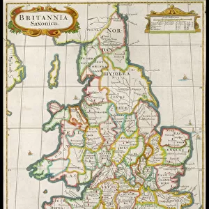
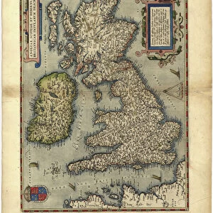
Fine Art Print : A Topographical Dictionary of Wales, map of North and South Wales, 19th century engraving


![]()
Fine Art Prints from Liszt Collection
A Topographical Dictionary of Wales, map of North and South Wales, 19th century engraving
Liszt Collection of nineteenth-century engravings and images to browse and enjoy
Media ID 12806309
© Quint Lox Limited
North South Wales Topographical Dictionary Wales
A2 (42x59cm) Fine Art Print
Step back in time with our exquisite selection from the Media Storehouse Fine Art Prints range. This captivating piece showcases an antique topographical map of North and South Wales, hailing from the 19th century. Meticulously engraved and part of the esteemed Liszt Collection, this detailed and intricately designed map transports you to a bygone era. Perfect for those who appreciate history, art, or the beauty of cartography, this fine art print adds an air of sophistication and character to any room in your home or office. Embrace the charm of the past with this stunning, vintage representation of Wales.
Our Fine Art Prints are printed on 100% acid free, PH neutral paper with archival properties. This printing method is used by museums and art collections to exhibit photographs and art reproductions. Hahnemühle certified studio for digital fine art printing. Printed on 308gsm Photo Rag Paper.
Our fine art prints are high-quality prints made using a paper called Photo Rag. This 100% cotton rag fibre paper is known for its exceptional image sharpness, rich colors, and high level of detail, making it a popular choice for professional photographers and artists. Photo rag paper is our clear recommendation for a fine art paper print. If you can afford to spend more on a higher quality paper, then Photo Rag is our clear recommendation for a fine art paper print.
Estimated Image Size (if not cropped) is 42cm x 47.7cm (16.5" x 18.8")
Estimated Product Size is 42cm x 59.4cm (16.5" x 23.4")
These are individually made so all sizes are approximate
Artwork printed orientated as per the preview above, with portrait (vertical) orientation to match the source image.
FEATURES IN THESE COLLECTIONS
> Europe
> United Kingdom
> Wales
> Maps
> Europe
> United Kingdom
> Wales
> Posters
> Europe
> United Kingdom
> Wales
> Related Images
> Maps and Charts
> Related Images
> Maps and Charts
> Wales
EDITORS COMMENTS
This 19th-century engraving from the Liszt Collection showcases a remarkable map of North and South Wales, extracted from "A Topographical Dictionary of Wales". A true testament to the artistry and precision of cartography during this era, this print offers a glimpse into the rich history and topography of these Welsh regions. The intricate details etched on this map provide an immersive experience for any viewer. From the rolling hills and valleys to the meandering rivers that crisscross both North and South Wales, every feature is meticulously depicted with utmost accuracy. The names of towns, villages, and landmarks are elegantly inscribed, allowing one to trace their finger along ancient paths once traveled by generations past. As we delve deeper into this enchanting print, it becomes evident that it holds more than just geographical significance. It serves as a portal through time, transporting us back to an era where exploration was paramount. This historical artifact not only educates but also evokes a sense of wonderment about how our world has evolved over centuries. Whether you have Welsh ancestry or simply appreciate the beauty found in old maps, this exquisite engraving will undoubtedly captivate your imagination. Its presence on your wall will serve as a constant reminder of the rich cultural heritage embedded within Wales' landscapes—a timeless piece that connects us to our roots while celebrating human ingenuity in capturing nature's wonders.
MADE IN THE UK
Safe Shipping with 30 Day Money Back Guarantee
FREE PERSONALISATION*
We are proud to offer a range of customisation features including Personalised Captions, Color Filters and Picture Zoom Tools
SECURE PAYMENTS
We happily accept a wide range of payment options so you can pay for the things you need in the way that is most convenient for you
* Options may vary by product and licensing agreement. Zoomed Pictures can be adjusted in the Basket.