Jigsaw Puzzle > Europe > United Kingdom > Wales > Maps
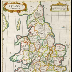
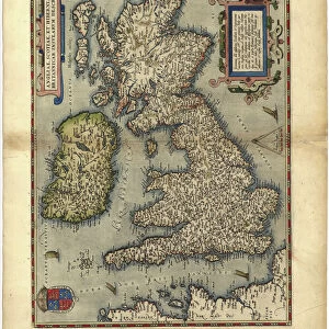
Jigsaw Puzzle : A Topographical Dictionary of Wales, map of North and South Wales, 19th century engraving


![]()
Jigsaw Puzzles from Liszt Collection
A Topographical Dictionary of Wales, map of North and South Wales, 19th century engraving
Liszt Collection of nineteenth-century engravings and images to browse and enjoy
Media ID 12806309
© Quint Lox Limited
North South Wales Topographical Dictionary Wales
Jigsaw Puzzle (500 Pieces)
Discover the captivating history of Wales with our exquisite Media Storehouse Jigsaw Puzzle featuring a rare 19th century engraving of the Topographical Dictionary of Wales map. This intricately detailed puzzle showcases the rich cartography of North and South Wales, transporting you back in time with every piece you place. The Liszt Collection's antique map, adorned with intricate borders and meticulous labeling, offers a fascinating glimpse into the geography and cultural heritage of this beautiful country. Unraveling this puzzle is not just an enjoyable pastime, but a journey through time and space. Gather your family and friends for a memorable experience, and let the adventure begin!
500 piece puzzles are custom made in the UK and hand-finished on 100% recycled 1.5 mm millboard. There is a level of repetition in jigsaw shapes with each matching piece away from its pair. The completed puzzle measures 38x50cm and is delivered packaged in an attractive presentation box specially designed to fit most letter box slots
Jigsaw Puzzles are an ideal gift for any occasion
Estimated Product Size is 38cm x 50.2cm (15" x 19.8")
These are individually made so all sizes are approximate
Artwork printed orientated as per the preview above, with landscape (horizontal) or portrait (vertical) orientation to match the source image.
FEATURES IN THESE COLLECTIONS
> Europe
> United Kingdom
> Wales
> Maps
> Europe
> United Kingdom
> Wales
> Posters
> Europe
> United Kingdom
> Wales
> Related Images
> Maps and Charts
> Related Images
> Maps and Charts
> Wales
EDITORS COMMENTS
This 19th-century engraving from the Liszt Collection showcases a remarkable map of North and South Wales, extracted from "A Topographical Dictionary of Wales". A true testament to the artistry and precision of cartography during this era, this print offers a glimpse into the rich history and topography of these Welsh regions. The intricate details etched on this map provide an immersive experience for any viewer. From the rolling hills and valleys to the meandering rivers that crisscross both North and South Wales, every feature is meticulously depicted with utmost accuracy. The names of towns, villages, and landmarks are elegantly inscribed, allowing one to trace their finger along ancient paths once traveled by generations past. As we delve deeper into this enchanting print, it becomes evident that it holds more than just geographical significance. It serves as a portal through time, transporting us back to an era where exploration was paramount. This historical artifact not only educates but also evokes a sense of wonderment about how our world has evolved over centuries. Whether you have Welsh ancestry or simply appreciate the beauty found in old maps, this exquisite engraving will undoubtedly captivate your imagination. Its presence on your wall will serve as a constant reminder of the rich cultural heritage embedded within Wales' landscapes—a timeless piece that connects us to our roots while celebrating human ingenuity in capturing nature's wonders.
MADE IN THE UK
Safe Shipping with 30 Day Money Back Guarantee
FREE PERSONALISATION*
We are proud to offer a range of customisation features including Personalised Captions, Color Filters and Picture Zoom Tools
SECURE PAYMENTS
We happily accept a wide range of payment options so you can pay for the things you need in the way that is most convenient for you
* Options may vary by product and licensing agreement. Zoomed Pictures can be adjusted in the Basket.