Premium Framed Print > Europe > France > Canton > Loire
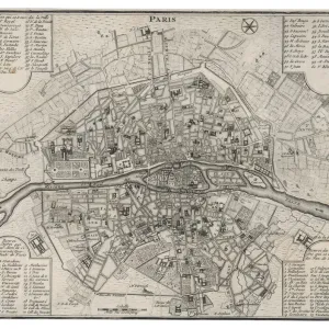
Premium Framed Print : 1852, Levasseur Map of the Department De Maine et Loire, France, topography, cartography


![]()
Framed Photos from Liszt Collection
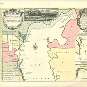
1852, Levasseur Map of the Department De Maine et Loire, France, topography, cartography
1852, Levasseur Map of the Department De Maine et Loire, France
Liszt Collection of nineteenth-century engravings and images to browse and enjoy
Media ID 14005291
© Artokoloro Quint Lox Limited
1852 Antique Map Latitude Longitude Mappa Mundi Old Antique Plan Old Antique View Ols Antique Map Rare Old Maps Topo
17"x15" (43x38cm) Premium Frame
FSC real wood frame with double mounted 10x8 print. Double mounted with white conservation mountboard. Frame moulding comprises stained composite natural wood veneers (Finger Jointed Pine) 39mm wide by 21mm thick. Archival quality Fujifilm CA photo paper mounted onto 1mm card. Overall outside dimensions are 17x15 inches (431x381mm). Rear features Framing tape to cover staples, 50mm Hanger plate, cork bumpers. Glazed with durable thick 2mm Acrylic to provide a virtually unbreakable glass-like finish. Acrylic Glass is far safer, more flexible and much lighter than typical mineral glass. Moreover, its higher translucency makes it a perfect carrier for photo prints. Acrylic allows a little more light to penetrate the surface than conventional glass and absorbs UV rays so that the image and the picture quality doesn't suffer under direct sunlight even after many years. Easily cleaned with a damp cloth. Please note that, to prevent the paper falling through the mount window and to prevent cropping of the original artwork, the visible print may be slightly smaller to allow the paper to be securely attached to the mount without any white edging showing and to match the aspect ratio of the original artwork.
FSC Real Wood Frame and Double Mounted with White Conservation Mountboard - Professionally Made and Ready to Hang
Estimated Image Size (if not cropped) is 24.4cm x 17.1cm (9.6" x 6.7")
Estimated Product Size is 43.1cm x 38.1cm (17" x 15")
These are individually made so all sizes are approximate
Artwork printed orientated as per the preview above, with landscape (horizontal) orientation to match the source image.
FEATURES IN THESE COLLECTIONS
> Europe
> France
> Canton
> Landes
> Europe
> France
> Canton
> Loire
> Europe
> France
> Canton
> Maine
> Historic
> Space exploration
> Maps and Charts
> Early Maps
> Maps and Charts
> Related Images
> Maps and Charts
> World
EDITORS COMMENTS
This print showcases the exquisite 1852 Levasseur Map of the Department De Maine et Loire, France. A true masterpiece in topography and cartography, this vintage map offers a fascinating glimpse into the geography and land of this historic region. With its intricate illustration and precise geographic details, it serves as a remarkable tool for navigation and exploration. The aged paper exudes an aura of history, taking us back to a bygone era when maps were meticulously crafted by hand. Its decorative elements add an artistic touch to this historical artifact, making it not only informative but also visually appealing. As we delve into the past through this rare old map, we are transported on a journey of discovery. It reminds us of the importance placed on understanding our world's geography long before modern technology made it easily accessible. The latitude and longitude grid provides a sense of order amidst the vastness of Earth's landscapes. With its antique charm and rich historical significance, this Levasseur Map is more than just a piece of paper; it represents an invaluable link to our past. Whether you are an avid collector or simply appreciate artful relics from yesteryears, this print is sure to captivate your imagination with its timeless beauty.
MADE IN THE UK
Safe Shipping with 30 Day Money Back Guarantee
FREE PERSONALISATION*
We are proud to offer a range of customisation features including Personalised Captions, Color Filters and Picture Zoom Tools
SECURE PAYMENTS
We happily accept a wide range of payment options so you can pay for the things you need in the way that is most convenient for you
* Options may vary by product and licensing agreement. Zoomed Pictures can be adjusted in the Basket.