Premium Framed Print > Historic > Ancient civilizations > Ancient Greece > Athens
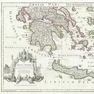
Premium Framed Print : 1784, Bocage Map of the City of Athens in Ancient Greece, topography, cartography


![]()
Framed Photos from Liszt Collection
1784, Bocage Map of the City of Athens in Ancient Greece, topography, cartography
1784, Bocage Map of the City of Athens in Ancient Greece
Liszt Collection of nineteenth-century engravings and images to browse and enjoy
Media ID 14006840
© Artokoloro Quint Lox Limited
1784 Antique Map Latitude Longitude Mappa Mundi Old Antique Plan Old Antique View Ols Antique Map Rare Old Maps Topo
17"x15" (43x38cm) Premium Frame
FSC real wood frame with double mounted 10x8 print. Double mounted with white conservation mountboard. Frame moulding comprises stained composite natural wood veneers (Finger Jointed Pine) 39mm wide by 21mm thick. Archival quality Fujifilm CA photo paper mounted onto 1mm card. Overall outside dimensions are 17x15 inches (431x381mm). Rear features Framing tape to cover staples, 50mm Hanger plate, cork bumpers. Glazed with durable thick 2mm Acrylic to provide a virtually unbreakable glass-like finish. Acrylic Glass is far safer, more flexible and much lighter than typical mineral glass. Moreover, its higher translucency makes it a perfect carrier for photo prints. Acrylic allows a little more light to penetrate the surface than conventional glass and absorbs UV rays so that the image and the picture quality doesn't suffer under direct sunlight even after many years. Easily cleaned with a damp cloth. Please note that, to prevent the paper falling through the mount window and to prevent cropping of the original artwork, the visible print may be slightly smaller to allow the paper to be securely attached to the mount without any white edging showing and to match the aspect ratio of the original artwork.
FSC Real Wood Frame and Double Mounted with White Conservation Mountboard - Professionally Made and Ready to Hang
Estimated Image Size (if not cropped) is 24.4cm x 19.8cm (9.6" x 7.8")
Estimated Product Size is 43.1cm x 38.1cm (17" x 15")
These are individually made so all sizes are approximate
Artwork printed orientated as per the preview above, with landscape (horizontal) orientation to match the source image.
FEATURES IN THESE COLLECTIONS
> Europe
> France
> Canton
> Landes
> Europe
> Greece
> Related Images
> Historic
> Ancient civilizations
> Ancient Greece
> Athens
> Historic
> Ancient civilizations
> Ancient Greece
> Greek history
> Historic
> Space exploration
> Maps and Charts
> Early Maps
EDITORS COMMENTS
This print showcases the exquisite 1784 Bocage Map of the City of Athens in Ancient Greece. A true masterpiece in topography and cartography, this vintage map offers a fascinating glimpse into the ancient world. With its intricate details and precise measurements, it serves as a valuable historical artifact that transports us back to a time long gone. The artistry behind this map is truly remarkable. Every contour, every street, and every landmark is meticulously illustrated with stunning accuracy. Its delicate lines form an intricate grid of latitude and longitude, allowing viewers to navigate through the city's rich history effortlessly. As we gaze upon this aged piece of art, we are reminded of the countless journeys and discoveries made by explorers who once relied on such maps for navigation. It evokes a sense of wonderment about our planet's past and ignites our curiosity about civilizations that thrived centuries ago. With its decorative appeal, this antique map adds a touch of elegance to any space it graces. Whether displayed in a study or framed on a wall, it becomes both an educational tool and an object d'art that sparks conversations about ancient cultures. The Liszt Collection has preserved this rare gem from history for all to admire—a testament to their dedication in safeguarding our collective heritage.
MADE IN THE UK
Safe Shipping with 30 Day Money Back Guarantee
FREE PERSONALISATION*
We are proud to offer a range of customisation features including Personalised Captions, Color Filters and Picture Zoom Tools
SECURE PAYMENTS
We happily accept a wide range of payment options so you can pay for the things you need in the way that is most convenient for you
* Options may vary by product and licensing agreement. Zoomed Pictures can be adjusted in the Basket.