Premium Framed Print > South America > Chile > Maps
Premium Framed Print : Map of Peru, c1599. Artist: Arnoldus Florentius


![]()
Framed Photos from Heritage Images
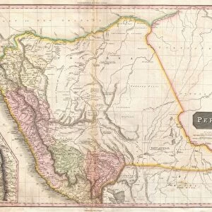
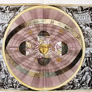
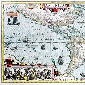
Map of Peru, c1599. Artist: Arnoldus Florentius
Map of Peru, c1599. A map of South America and the Caribbean, with Chile, Peru, Brazil, Cuba and Florida. From Adventures By Sea From Art of Old Time, by Basil Lubbock. [The Studio Ltd. London, 1925]
Heritage Images features heritage image collections
Media ID 14978633
© The Print Collector
Basil Basil Lubbock Cartography Lubbock Map Making Peru Arnoldus
17"x15" (43x38cm) Premium Frame
FSC real wood frame with double mounted 10x8 print. Double mounted with white conservation mountboard. Frame moulding comprises stained composite natural wood veneers (Finger Jointed Pine) 39mm wide by 21mm thick. Archival quality Fujifilm CA photo paper mounted onto 1mm card. Overall outside dimensions are 17x15 inches (431x381mm). Rear features Framing tape to cover staples, 50mm Hanger plate, cork bumpers. Glazed with durable thick 2mm Acrylic to provide a virtually unbreakable glass-like finish. Acrylic Glass is far safer, more flexible and much lighter than typical mineral glass. Moreover, its higher translucency makes it a perfect carrier for photo prints. Acrylic allows a little more light to penetrate the surface than conventional glass and absorbs UV rays so that the image and the picture quality doesn't suffer under direct sunlight even after many years. Easily cleaned with a damp cloth. Please note that, to prevent the paper falling through the mount window and to prevent cropping of the original artwork, the visible print may be slightly smaller to allow the paper to be securely attached to the mount without any white edging showing and to match the aspect ratio of the original artwork.
FSC Real Wood Frame and Double Mounted with White Conservation Mountboard - Professionally Made and Ready to Hang
Estimated Image Size (if not cropped) is 24.4cm x 17cm (9.6" x 6.7")
Estimated Product Size is 43.1cm x 38.1cm (17" x 15")
These are individually made so all sizes are approximate
Artwork printed orientated as per the preview above, with landscape (horizontal) orientation to match the source image.
FEATURES IN THESE COLLECTIONS
> Heritage Images
> Maps Charts & Plans
> Maps and Charts
> Related Images
> North America
> Cuba
> Maps
> North America
> Cuba
> Related Images
> South America
> Brazil
> Maps
> South America
> Brazil
> Related Images
> South America
> Chile
> Maps
> South America
> Chile
> Related Images
> South America
> Peru
> Maps
> South America
> Peru
> Related Images
EDITORS COMMENTS
This print showcases a remarkable piece of cartographic history - the "Map of Peru, c1599" by Arnoldus Florentius. Created during the 16th century, this map offers a fascinating glimpse into the geographical knowledge and artistic skills of that era. The intricate details and vibrant colors bring to life South America and the Caribbean region, including Chile, Peru, Brazil, Cuba, and Florida. It is an invaluable resource for understanding how these areas were perceived in the past. As we delve into this historical artifact from "Adventures By Sea From Art of Old Time" authored by Basil Lubbock in 1925, we are transported back in time. The careful craftsmanship evident in every stroke reveals Florentius' dedication to accuracy and his mastery as a cartographer. This print not only serves as a visual delight but also provides valuable insights into the evolution of map-making techniques over centuries. It reminds us of our ancestors' thirst for exploration and their relentless pursuit to chart unknown territories accurately. Preserved with utmost care by The Print Collector29 at The Studio Ltd. , London; it stands as a testament to their commitment to preserving our rich cultural heritage. Let this magnificent artwork transport you through time as you marvel at its beauty while appreciating its significance in shaping our understanding of geography throughout history.
MADE IN THE UK
Safe Shipping with 30 Day Money Back Guarantee
FREE PERSONALISATION*
We are proud to offer a range of customisation features including Personalised Captions, Color Filters and Picture Zoom Tools
SECURE PAYMENTS
We happily accept a wide range of payment options so you can pay for the things you need in the way that is most convenient for you
* Options may vary by product and licensing agreement. Zoomed Pictures can be adjusted in the Basket.