Premium Framed Print > Arts > Artists > C > Samuel de Champlain
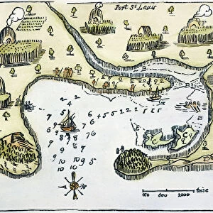
Premium Framed Print : MAP: PORT ST. LOUIS, 1605. Samuel de Champlains map of Port St


![]()
Framed Photos from Granger
MAP: PORT ST. LOUIS, 1605. Samuel de Champlains map of Port St
MAP: PORT ST. LOUIS, 1605.
Samuel de Champlains map of Port St. Louis, later settled by the English as Plymoth, Massachusetts, drawn during an expedition of 1605
Granger holds millions of images spanning more than 25,000 years of world history, from before the Stone Age to the dawn of the Space Age
Media ID 12568329
1605 Champlain Colony Exploration Harbor Pilgrim Plymouth Samuel Settlement Topography United States Wampanoag
17"x15" (43x38cm) Premium Frame
FSC real wood frame with double mounted 10x8 print. Double mounted with white conservation mountboard. Frame moulding comprises stained composite natural wood veneers (Finger Jointed Pine) 39mm wide by 21mm thick. Archival quality Fujifilm CA photo paper mounted onto 1mm card. Overall outside dimensions are 17x15 inches (431x381mm). Rear features Framing tape to cover staples, 50mm Hanger plate, cork bumpers. Glazed with durable thick 2mm Acrylic to provide a virtually unbreakable glass-like finish. Acrylic Glass is far safer, more flexible and much lighter than typical mineral glass. Moreover, its higher translucency makes it a perfect carrier for photo prints. Acrylic allows a little more light to penetrate the surface than conventional glass and absorbs UV rays so that the image and the picture quality doesn't suffer under direct sunlight even after many years. Easily cleaned with a damp cloth. Please note that, to prevent the paper falling through the mount window and to prevent cropping of the original artwork, the visible print may be slightly smaller to allow the paper to be securely attached to the mount without any white edging showing and to match the aspect ratio of the original artwork.
FSC Real Wood Frame and Double Mounted with White Conservation Mountboard - Professionally Made and Ready to Hang
Estimated Image Size (if not cropped) is 24.4cm x 17.3cm (9.6" x 6.8")
Estimated Product Size is 43.1cm x 38.1cm (17" x 15")
These are individually made so all sizes are approximate
Artwork printed orientated as per the preview above, with landscape (horizontal) orientation to match the source image.
FEATURES IN THESE COLLECTIONS
> Granger Art on Demand
> U.S. States
> Arts
> Artists
> C
> Samuel de Champlain
> Maps and Charts
> Related Images
EDITORS COMMENTS
This print showcases Samuel de Champlain's map of Port St. Louis, drawn during his expedition in 1605. The intricate details and topography depicted on the map provide a fascinating glimpse into the early exploration and settlement of North America. Port St. Louis, later known as Plymouth, Massachusetts, holds immense historical significance as one of the first English colonies established in America. This map serves as a visual testament to the beginnings of this iconic settlement. As we delve into this piece, we are transported back in time to an era when Native American tribes like the Wampanoag inhabited these lands alongside European explorers and settlers. The convergence of cultures is palpable through Champlain's depiction of Indian villages along the river. The woodcut style adds a rustic charm to this print, further enhancing its nostalgic appeal. It invites us to ponder upon the challenges faced by those who embarked on these expeditions centuries ago. Whether you are an avid history enthusiast or simply appreciate art that tells stories from our past, this print is sure to captivate your imagination and spark curiosity about America's colonial heritage.
MADE IN THE UK
Safe Shipping with 30 Day Money Back Guarantee
FREE PERSONALISATION*
We are proud to offer a range of customisation features including Personalised Captions, Color Filters and Picture Zoom Tools
SECURE PAYMENTS
We happily accept a wide range of payment options so you can pay for the things you need in the way that is most convenient for you
* Options may vary by product and licensing agreement. Zoomed Pictures can be adjusted in the Basket.