Framed Print > Arts > Artists > C > Samuel de Champlain
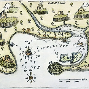
Framed Print : MAP: PORT ST. LOUIS, 1605. Samuel de Champlains map of Port St


![]()
Framed Photos from Granger
MAP: PORT ST. LOUIS, 1605. Samuel de Champlains map of Port St
MAP: PORT ST. LOUIS, 1605.
Samuel de Champlains map of Port St. Louis, later settled by the English as Plymoth, Massachusetts, drawn during an expedition of 1605
Granger holds millions of images spanning more than 25,000 years of world history, from before the Stone Age to the dawn of the Space Age
Media ID 12568329
1605 Champlain Colony Exploration Harbor Pilgrim Plymouth Samuel Settlement Topography United States Wampanoag
14"x12" (38x32cm) Modern Frame
Step back in time with our exquisite framed print, featuring the historic map of Port St. Louis, 1605 by Samuel de Champlain. This captivating piece showcases the explorer's original map of the Port St. Louis area, later known as Plymoth, Massachusetts. The intricate details of the map depict the early settlements, waterways, and territories explored during Champlain's expedition. Add a touch of history and sophistication to your home or office with this beautiful, museum-quality framed print. Each print is carefully crafted with archival materials to ensure lasting beauty and preservation. Order yours today and let the story of 17th-century exploration unfold in your space.
Wood effect frame, card mounted, 10x8 archival quality photo print. Overall outside dimensions 14x12 inches (38x32cm). Environmentally and ozone friendly, 40mm wide x 15mm Polycore® moulding has the look of real wood, is durable and light and easy to hang. Biodegradable and made with non-chlorinated gases (no toxic fumes) it is efficient; producing 100 tons of polystyrene can save 300 tons of trees! Prints are glazed with lightweight, shatterproof, optical clarity acrylic (providing the same general protection from the environment as glass). The back is stapled hardboard with a sawtooth hanger attached. Note: To minimise original artwork cropping, for optimum layout, and to ensure print is secure, the visible print may be marginally smaller
Contemporary Framed and Mounted Prints - Professionally Made and Ready to Hang
Estimated Image Size (if not cropped) is 24.4cm x 17.3cm (9.6" x 6.8")
Estimated Product Size is 37.6cm x 32.5cm (14.8" x 12.8")
These are individually made so all sizes are approximate
Artwork printed orientated as per the preview above, with landscape (horizontal) orientation to match the source image.
FEATURES IN THESE COLLECTIONS
> Arts
> Artists
> C
> Samuel de Champlain
> Maps and Charts
> Related Images
> Granger Art on Demand
> U.S. States
EDITORS COMMENTS
This print showcases Samuel de Champlain's map of Port St. Louis, drawn during his expedition in 1605. The intricate details and topography depicted on the map provide a fascinating glimpse into the early exploration and settlement of North America. Port St. Louis, later known as Plymouth, Massachusetts, holds immense historical significance as one of the first English colonies established in America. This map serves as a visual testament to the beginnings of this iconic settlement. As we delve into this piece, we are transported back in time to an era when Native American tribes like the Wampanoag inhabited these lands alongside European explorers and settlers. The convergence of cultures is palpable through Champlain's depiction of Indian villages along the river. The woodcut style adds a rustic charm to this print, further enhancing its nostalgic appeal. It invites us to ponder upon the challenges faced by those who embarked on these expeditions centuries ago. Whether you are an avid history enthusiast or simply appreciate art that tells stories from our past, this print is sure to captivate your imagination and spark curiosity about America's colonial heritage.
MADE IN THE UK
Safe Shipping with 30 Day Money Back Guarantee
FREE PERSONALISATION*
We are proud to offer a range of customisation features including Personalised Captions, Color Filters and Picture Zoom Tools
SECURE PAYMENTS
We happily accept a wide range of payment options so you can pay for the things you need in the way that is most convenient for you
* Options may vary by product and licensing agreement. Zoomed Pictures can be adjusted in the Basket.