Premium Framed Print > Asia > China > Maps
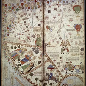
Premium Framed Print : China country map


![]()
Framed Photos from Fine Art Storehouse
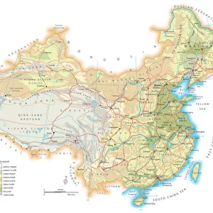
China country map
2011 edition
Unleash your creativity and transform your space into a visual masterpiece!
Media ID 14432445
17"x15" (43x38cm) Premium Frame
FSC real wood frame with double mounted 10x8 print. Double mounted with white conservation mountboard. Frame moulding comprises stained composite natural wood veneers (Finger Jointed Pine) 39mm wide by 21mm thick. Archival quality Fujifilm CA photo paper mounted onto 1mm card. Overall outside dimensions are 17x15 inches (431x381mm). Rear features Framing tape to cover staples, 50mm Hanger plate, cork bumpers. Glazed with durable thick 2mm Acrylic to provide a virtually unbreakable glass-like finish. Acrylic Glass is far safer, more flexible and much lighter than typical mineral glass. Moreover, its higher translucency makes it a perfect carrier for photo prints. Acrylic allows a little more light to penetrate the surface than conventional glass and absorbs UV rays so that the image and the picture quality doesn't suffer under direct sunlight even after many years. Easily cleaned with a damp cloth. Please note that, to prevent the paper falling through the mount window and to prevent cropping of the original artwork, the visible print may be slightly smaller to allow the paper to be securely attached to the mount without any white edging showing and to match the aspect ratio of the original artwork.
FSC Real Wood Frame and Double Mounted with White Conservation Mountboard - Professionally Made and Ready to Hang
Estimated Image Size (if not cropped) is 24.4cm x 18.4cm (9.6" x 7.2")
Estimated Product Size is 43.1cm x 38.1cm (17" x 15")
These are individually made so all sizes are approximate
Artwork printed orientated as per the preview above, with landscape (horizontal) orientation to match the source image.
FEATURES IN THESE COLLECTIONS
> Fine Art Storehouse
> Map
> Reference Maps
> Maps and Charts
> Related Images
EDITORS COMMENTS
This print showcases the intricate details of a China country map from the 2011 edition, carefully curated by Fine Art Storehouse. With its rich colors and precise cartographic markings, this piece is an exquisite representation of one of the world's most culturally diverse nations. The map effortlessly captures China's vast landscapes, spanning from the majestic Himalayan mountain range in the southwest to the sprawling plains in the northeast. Every province and autonomous region is intricately labeled, allowing viewers to explore each area's unique characteristics and historical significance. As you delve into this artwork, your eyes will be drawn to iconic landmarks such as The Great Wall snaking through northern China or cities like Beijing with its imperial palaces and modern skyscrapers. This print serves as a visual gateway for those seeking to understand China's complex history, geography, and cultural heritage. Whether you are an avid traveler planning your next adventure or simply fascinated by global diversity, this print offers a window into one of humanity's oldest civilizations. Its meticulous attention to detail makes it not only visually stunning but also educational—a perfect addition to any art collection or study space.
MADE IN THE UK
Safe Shipping with 30 Day Money Back Guarantee
FREE PERSONALISATION*
We are proud to offer a range of customisation features including Personalised Captions, Color Filters and Picture Zoom Tools
SECURE PAYMENTS
We happily accept a wide range of payment options so you can pay for the things you need in the way that is most convenient for you
* Options may vary by product and licensing agreement. Zoomed Pictures can be adjusted in the Basket.