Home > Arts > Landscape paintings > Waterfall and river artworks > River artworks
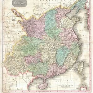
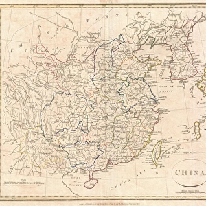
MAP: CHINA, 1910. Map of China published in Germany, 1910

![]()
Wall Art and Photo Gifts from Granger
MAP: CHINA, 1910. Map of China published in Germany, 1910
Granger holds millions of images spanning more than 25,000 years of world history, from before the Stone Age to the dawn of the Space Age
Media ID 6617649
FEATURES IN THESE COLLECTIONS
> Arts
> Landscape paintings
> Waterfall and river artworks
> River artworks
> Granger Art on Demand
> Maps
> Maps and Charts
> Early Maps
EDITORS COMMENTS
This print showcases a remarkable piece of history - a map of China published in Germany back in 1910. The intricate details and precision of this cartographic masterpiece transport us to an era long gone, offering a glimpse into the world as it was over a century ago. The map itself is an exquisite representation of China's vast landscape, with its sprawling rivers, majestic mountains, and bustling cities. It serves as a testament to the artistry and dedication that went into creating such comprehensive geographical records during that time. Published by The Granger Collection, this particular print holds immense historical value. It allows us to explore the early Chinese civilization through the lens of German cartographers who meticulously documented every aspect of the country's geography. As we study this artifact from yesteryears, we can't help but marvel at how much has changed since then - borders shifted, cities expanded, and landscapes transformed. Beyond its educational significance lies an aesthetic appeal that draws us in. The vintage charm exuded by this aged map adds character to any space it graces. Whether displayed within classrooms or adorning personal collections at home, this print sparks curiosity about our past while simultaneously serving as an artistic statement. In essence, "MAP: CHINA 1910" transports us on a visual journey through time - inviting contemplation on both historical events and cultural heritage alike.
MADE IN THE UK
Safe Shipping with 30 Day Money Back Guarantee
FREE PERSONALISATION*
We are proud to offer a range of customisation features including Personalised Captions, Color Filters and Picture Zoom Tools
SECURE PAYMENTS
We happily accept a wide range of payment options so you can pay for the things you need in the way that is most convenient for you
* Options may vary by product and licensing agreement. Zoomed Pictures can be adjusted in the Basket.