Premium Framed Print > Europe > France > Maps
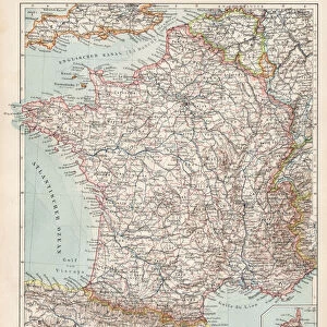
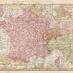
Premium Framed Print : Map of France 1889


![]()
Framed Photos from Fine Art Storehouse
Map of France 1889
Comprehensive Geography by James Monteith - American Book Company 1882, 1889
Unleash your creativity and transform your space into a visual masterpiece!
THEPALMER
Media ID 18357313
17"x15" (43x38cm) Premium Frame
FSC real wood frame with double mounted 10x8 print. Double mounted with white conservation mountboard. Frame moulding comprises stained composite natural wood veneers (Finger Jointed Pine) 39mm wide by 21mm thick. Archival quality Fujifilm CA photo paper mounted onto 1mm card. Overall outside dimensions are 17x15 inches (431x381mm). Rear features Framing tape to cover staples, 50mm Hanger plate, cork bumpers. Glazed with durable thick 2mm Acrylic to provide a virtually unbreakable glass-like finish. Acrylic Glass is far safer, more flexible and much lighter than typical mineral glass. Moreover, its higher translucency makes it a perfect carrier for photo prints. Acrylic allows a little more light to penetrate the surface than conventional glass and absorbs UV rays so that the image and the picture quality doesn't suffer under direct sunlight even after many years. Easily cleaned with a damp cloth. Please note that, to prevent the paper falling through the mount window and to prevent cropping of the original artwork, the visible print may be slightly smaller to allow the paper to be securely attached to the mount without any white edging showing and to match the aspect ratio of the original artwork.
FSC Real Wood Frame and Double Mounted with White Conservation Mountboard - Professionally Made and Ready to Hang
Estimated Image Size (if not cropped) is 24.4cm x 18.4cm (9.6" x 7.2")
Estimated Product Size is 43.1cm x 38.1cm (17" x 15")
These are individually made so all sizes are approximate
Artwork printed orientated as per the preview above, with landscape (horizontal) orientation to match the source image.
FEATURES IN THESE COLLECTIONS
> Fine Art Storehouse
> Map
> Historical Maps
> Maps and Charts
> Related Images
EDITORS COMMENTS
This print showcases a remarkable piece of history - the "Map of France 1889" from James Monteith's Comprehensive Geography, published by the American Book Company in 1882 and updated in 1889. Captured by THEPALMER, this image transports us back to an era when cartography was meticulously handcrafted. The map itself is a testament to the artistry and precision that went into creating these invaluable geographical resources. Every contour, river, city, and border has been intricately detailed with utmost care. It serves as a window into France's past, offering insights into its political boundaries and topographical features during that time period. As we gaze upon this vintage masterpiece, we can't help but marvel at how far our understanding of geography has evolved since then. Yet it also reminds us of the enduring importance of maps as tools for exploration and knowledge dissemination. THEPALMER's expert photography captures every nuance of this historical artifact with stunning clarity. The rich colors and intricate details bring the map to life on paper, making it an ideal addition to any collector or history enthusiast's collection. Whether displayed in a classroom or adorning the walls of a home library, this print invites viewers on a journey through time while celebrating both the beauty and educational significance found within antique maps like this one from Fine Art Storehouse.
MADE IN THE UK
Safe Shipping with 30 Day Money Back Guarantee
FREE PERSONALISATION*
We are proud to offer a range of customisation features including Personalised Captions, Color Filters and Picture Zoom Tools
SECURE PAYMENTS
We happily accept a wide range of payment options so you can pay for the things you need in the way that is most convenient for you
* Options may vary by product and licensing agreement. Zoomed Pictures can be adjusted in the Basket.