Photo Mug > Europe > France > Maps
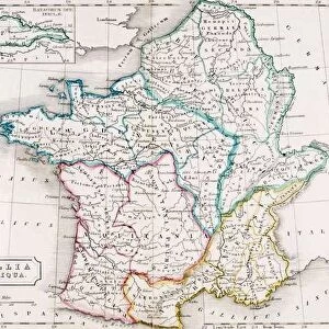
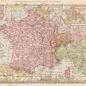
Photo Mug : Map of France 1889


![]()
Home Decor from Fine Art Storehouse
Map of France 1889
Comprehensive Geography by James Monteith - American Book Company 1882, 1889
Unleash your creativity and transform your space into a visual masterpiece!
THEPALMER
Media ID 18357313
Photo Mug
"Bring a piece of historical cartography to your morning routine with our Media Storehouse Photo Mug featuring the intricately detailed "Map of France 1889" by THEPALMER. This vintage map, originally published in Comprehensive Geography by James Monteith - American Book Company in 1882 and 1889, is now available in a functional and stylish form. Each mug holds your favorite beverage while showcasing this captivating piece of cartographic history. Perfect for history enthusiasts, travelers, or anyone who appreciates the beauty of old maps. Enjoy your daily brew and reminisce about the past with every sip. "
A personalised photo mug blends sentimentality with functionality, making an ideal gift for cherished loved ones, close friends, or valued colleagues. Preview may show both sides of the same mug.
Elevate your coffee or tea experience with our premium white ceramic mug. Its wide, comfortable handle makes drinking easy, and you can rely on it to be both microwave and dishwasher safe. Sold in single units, preview may show both sides of the same mug so you can see how the picture wraps around.
Mug Size is 8cm high x 9.5cm diameter (3.1" x 3.7")
These are individually made so all sizes are approximate
FEATURES IN THESE COLLECTIONS
> Fine Art Storehouse
> Map
> Historical Maps
> Maps and Charts
> Related Images
EDITORS COMMENTS
This print showcases a remarkable piece of history - the "Map of France 1889" from James Monteith's Comprehensive Geography, published by the American Book Company in 1882 and updated in 1889. Captured by THEPALMER, this image transports us back to an era when cartography was meticulously handcrafted. The map itself is a testament to the artistry and precision that went into creating these invaluable geographical resources. Every contour, river, city, and border has been intricately detailed with utmost care. It serves as a window into France's past, offering insights into its political boundaries and topographical features during that time period. As we gaze upon this vintage masterpiece, we can't help but marvel at how far our understanding of geography has evolved since then. Yet it also reminds us of the enduring importance of maps as tools for exploration and knowledge dissemination. THEPALMER's expert photography captures every nuance of this historical artifact with stunning clarity. The rich colors and intricate details bring the map to life on paper, making it an ideal addition to any collector or history enthusiast's collection. Whether displayed in a classroom or adorning the walls of a home library, this print invites viewers on a journey through time while celebrating both the beauty and educational significance found within antique maps like this one from Fine Art Storehouse.
MADE IN THE UK
Safe Shipping with 30 Day Money Back Guarantee
FREE PERSONALISATION*
We are proud to offer a range of customisation features including Personalised Captions, Color Filters and Picture Zoom Tools
SECURE PAYMENTS
We happily accept a wide range of payment options so you can pay for the things you need in the way that is most convenient for you
* Options may vary by product and licensing agreement. Zoomed Pictures can be adjusted in the Basket.