Premium Framed Print > Europe > Germany > Bielefeld
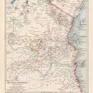
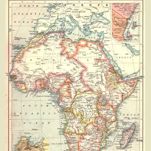
Premium Framed Print : German East Africa map 1896


![]()
Framed Photos from Fine Art Storehouse
German East Africa map 1896
Andres Allgemeiner Handatlas - Bielefeld und Leipzig 1896
Unleash your creativity and transform your space into a visual masterpiece!
THEPALMER
Media ID 18356855
23"x19" (58x48cm) Premium Frame
FSC real wood frame with double mounted 16x12 print. Double mounted with white conservation mountboard. Frame moulding comprises stained composite natural wood veneers (Finger Jointed Pine) 39mm wide by 21mm thick. Archival quality Fujifilm CA photo paper mounted onto 1mm card. Overall outside dimensions are 23x19 inches (584x482mm). Rear features Framing tape to cover staples, 50mm Hanger plate, cork bumpers. Glazed with durable thick 2mm Acrylic to provide a virtually unbreakable glass-like finish. Acrylic Glass is far safer, more flexible and much lighter than typical mineral glass. Moreover, its higher translucency makes it a perfect carrier for photo prints. Acrylic allows a little more light to penetrate the surface than conventional glass and absorbs UV rays so that the image and the picture quality doesn't suffer under direct sunlight even after many years. Easily cleaned with a damp cloth. Please note that, to prevent the paper falling through the mount window and to prevent cropping of the original artwork, the visible print may be slightly smaller to allow the paper to be securely attached to the mount without any white edging showing and to match the aspect ratio of the original artwork.
FSC Real Wood Frame and Double Mounted with White Conservation Mountboard - Professionally Made and Ready to Hang
Estimated Image Size (if not cropped) is 39.6cm x 26.1cm (15.6" x 10.3")
Estimated Product Size is 58.4cm x 48.2cm (23" x 19")
These are individually made so all sizes are approximate
Artwork printed orientated as per the preview above, with landscape (horizontal) orientation to match the source image.
FEATURES IN THESE COLLECTIONS
> Fine Art Storehouse
> Map
> Historical Maps
> Africa
> Related Images
> Europe
> Germany
> Bielefeld
> Europe
> Germany
> Related Images
> Maps and Charts
> Related Images
EDITORS COMMENTS
This print showcases a historical gem, the German East Africa map from 1896. A true testament to the art of cartography, this exquisite piece is sourced from Andres Allgemeiner Handatlas - Bielefeld und Leipzig 1896. With intricate details and meticulous craftsmanship, it offers a fascinating glimpse into the past. The map itself depicts the vast territory of German East Africa during its colonial era. Stretching across present-day Tanzania, Rwanda, Burundi, and parts of Mozambique and Kenya, this region was once under German rule. The borders are clearly defined with precision, showcasing towns, rivers, mountains, and other geographical features that were significant at that time. The vintage aesthetic adds an extra layer of charm to this photo print. Its sepia tones evoke nostalgia while preserving the authenticity of the original document. Whether you're a history enthusiast or simply appreciate fine art prints with cultural significance, this piece will undoubtedly captivate your imagination. "The Palmer" known for their exceptional curation in Fine Art Storehouse's collection brings forth yet another remarkable find through this photograph. As you admire this stunning reproduction on display in your home or office space, let it transport you back in time to an era when explorers ventured into uncharted territories and empires sought dominion over distant lands.
MADE IN THE UK
Safe Shipping with 30 Day Money Back Guarantee
FREE PERSONALISATION*
We are proud to offer a range of customisation features including Personalised Captions, Color Filters and Picture Zoom Tools
SECURE PAYMENTS
We happily accept a wide range of payment options so you can pay for the things you need in the way that is most convenient for you
* Options may vary by product and licensing agreement. Zoomed Pictures can be adjusted in the Basket.