Fine Art Print > Europe > Germany > Bielefeld
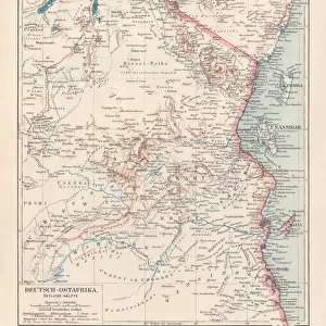
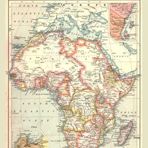
Fine Art Print : German East Africa map 1896


![]()
Fine Art Prints from Fine Art Storehouse
German East Africa map 1896
Andres Allgemeiner Handatlas - Bielefeld und Leipzig 1896
Unleash your creativity and transform your space into a visual masterpiece!
THEPALMER
Media ID 18356855
A2 (42x59cm) Fine Art Print
Discover the rich history of German East Africa with this stunning Fine Art Print from Media Storehouse. This exquisite reproduction is taken from the Andres Allgemeiner Handatlas map published in Bielefeld and Leipzig in 1896, featuring the detailed and intricate German East Africa map by THEPALMER. Transport yourself back in time as you explore the borders and territories of this historic region. Perfect for history enthusiasts, cartography collectors, or anyone looking to add a unique and educational piece to their home or office decor. Order now and bring a piece of the past into your space.
Our Fine Art Prints are printed on 100% acid free, PH neutral paper with archival properties. This printing method is used by museums and art collections to exhibit photographs and art reproductions. Hahnemühle certified studio for digital fine art printing. Printed on 308gsm Photo Rag Paper.
Our fine art prints are high-quality prints made using a paper called Photo Rag. This 100% cotton rag fibre paper is known for its exceptional image sharpness, rich colors, and high level of detail, making it a popular choice for professional photographers and artists. Photo rag paper is our clear recommendation for a fine art paper print. If you can afford to spend more on a higher quality paper, then Photo Rag is our clear recommendation for a fine art paper print.
Estimated Image Size (if not cropped) is 59.4cm x 39.1cm (23.4" x 15.4")
Estimated Product Size is 59.4cm x 42cm (23.4" x 16.5")
These are individually made so all sizes are approximate
Artwork printed orientated as per the preview above, with landscape (horizontal) orientation to match the source image.
FEATURES IN THESE COLLECTIONS
> Africa
> Related Images
> Europe
> Germany
> Bielefeld
> Europe
> Germany
> Related Images
> Maps and Charts
> Related Images
> Fine Art Storehouse
> Map
> Historical Maps
EDITORS COMMENTS
This print showcases a historical gem, the German East Africa map from 1896. A true testament to the art of cartography, this exquisite piece is sourced from Andres Allgemeiner Handatlas - Bielefeld und Leipzig 1896. With intricate details and meticulous craftsmanship, it offers a fascinating glimpse into the past. The map itself depicts the vast territory of German East Africa during its colonial era. Stretching across present-day Tanzania, Rwanda, Burundi, and parts of Mozambique and Kenya, this region was once under German rule. The borders are clearly defined with precision, showcasing towns, rivers, mountains, and other geographical features that were significant at that time. The vintage aesthetic adds an extra layer of charm to this photo print. Its sepia tones evoke nostalgia while preserving the authenticity of the original document. Whether you're a history enthusiast or simply appreciate fine art prints with cultural significance, this piece will undoubtedly captivate your imagination. "The Palmer" known for their exceptional curation in Fine Art Storehouse's collection brings forth yet another remarkable find through this photograph. As you admire this stunning reproduction on display in your home or office space, let it transport you back in time to an era when explorers ventured into uncharted territories and empires sought dominion over distant lands.
MADE IN THE UK
Safe Shipping with 30 Day Money Back Guarantee
FREE PERSONALISATION*
We are proud to offer a range of customisation features including Personalised Captions, Color Filters and Picture Zoom Tools
SECURE PAYMENTS
We happily accept a wide range of payment options so you can pay for the things you need in the way that is most convenient for you
* Options may vary by product and licensing agreement. Zoomed Pictures can be adjusted in the Basket.