Canvas Print > Europe > Germany > Bielefeld
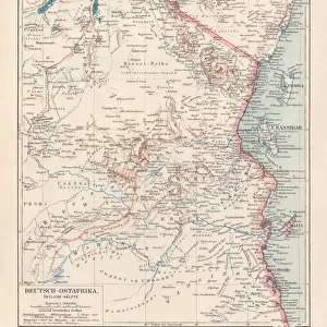
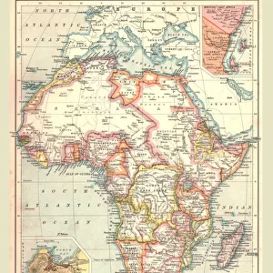
Canvas Print : German East Africa map 1896


![]()
Canvas Prints from Fine Art Storehouse
German East Africa map 1896
Andres Allgemeiner Handatlas - Bielefeld und Leipzig 1896
Unleash your creativity and transform your space into a visual masterpiece!
THEPALMER
Media ID 18356855
21"x14" (53x35cm) Canvas Print
Discover history with our exquisite Canvas Print of the German East Africa Map from 1896 by THEPALMER, taken from Andres Allgemeiner Handatlas published in Bielefeld and Leipzig. This fine art print transports you back in time, showcasing intricate details of the territories under German control during the colonial era. The high-quality canvas material adds depth and texture to the map's intricate lines and bold colors, making it a captivating addition to any room. Bring history into your home with this unique and authentic piece from Media Storehouse's Fine Art Collection.
Ready to hang Premium Gloss Canvas Print. Our archival quality canvas prints are made from Polyester and Cotton mix and stretched over a 1.25" (32mm) kiln dried knot free wood stretcher bar. Packaged in a plastic bag and secured to a cardboard insert for transit.
Canvas Prints add colour, depth and texture to any space. Professionally Stretched Canvas over a hidden Wooden Box Frame and Ready to Hang
Estimated Product Size is 53.3cm x 35.6cm (21" x 14")
These are individually made so all sizes are approximate
Artwork printed orientated as per the preview above, with landscape (horizontal) orientation to match the source image.
FEATURES IN THESE COLLECTIONS
> Africa
> Related Images
> Europe
> Germany
> Bielefeld
> Europe
> Germany
> Related Images
> Maps and Charts
> Related Images
> Fine Art Storehouse
> Map
> Historical Maps
EDITORS COMMENTS
This print showcases a historical gem, the German East Africa map from 1896. A true testament to the art of cartography, this exquisite piece is sourced from Andres Allgemeiner Handatlas - Bielefeld und Leipzig 1896. With intricate details and meticulous craftsmanship, it offers a fascinating glimpse into the past. The map itself depicts the vast territory of German East Africa during its colonial era. Stretching across present-day Tanzania, Rwanda, Burundi, and parts of Mozambique and Kenya, this region was once under German rule. The borders are clearly defined with precision, showcasing towns, rivers, mountains, and other geographical features that were significant at that time. The vintage aesthetic adds an extra layer of charm to this photo print. Its sepia tones evoke nostalgia while preserving the authenticity of the original document. Whether you're a history enthusiast or simply appreciate fine art prints with cultural significance, this piece will undoubtedly captivate your imagination. "The Palmer" known for their exceptional curation in Fine Art Storehouse's collection brings forth yet another remarkable find through this photograph. As you admire this stunning reproduction on display in your home or office space, let it transport you back in time to an era when explorers ventured into uncharted territories and empires sought dominion over distant lands.
MADE IN THE UK
Safe Shipping with 30 Day Money Back Guarantee
FREE PERSONALISATION*
We are proud to offer a range of customisation features including Personalised Captions, Color Filters and Picture Zoom Tools
SECURE PAYMENTS
We happily accept a wide range of payment options so you can pay for the things you need in the way that is most convenient for you
* Options may vary by product and licensing agreement. Zoomed Pictures can be adjusted in the Basket.