Premium Framed Print > Europe > United Kingdom > Northern Ireland > Maps
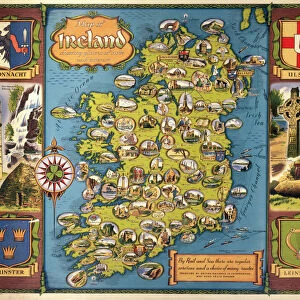
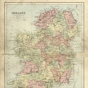
Premium Framed Print : Antique damaged map of Ireland in the 19th Century


![]()
Framed Photos from Fine Art Storehouse
Antique damaged map of Ireland in the 19th Century
Vintage engraving of a Antique damaged map of Ireland in the 19th Century, 1873
Unleash your creativity and transform your space into a visual masterpiece!
duncan1890
Media ID 13609233
© This content is subject to copyright
1870 1879 Bad Condition Colour Colours Condition Damaged Equipment Faded Great Britain Image Created 1870 1879 Ireland Navigational Equipment Northern Europe Northern Ireland Republic Of Ireland Retro Styles Supplies United Kingdom Victorian Retro Styled Victorian Style
17"x15" (43x38cm) Premium Frame
FSC real wood frame with double mounted 10x8 print. Double mounted with white conservation mountboard. Frame moulding comprises stained composite natural wood veneers (Finger Jointed Pine) 39mm wide by 21mm thick. Archival quality Fujifilm CA photo paper mounted onto 1mm card. Overall outside dimensions are 17x15 inches (431x381mm). Rear features Framing tape to cover staples, 50mm Hanger plate, cork bumpers. Glazed with durable thick 2mm Acrylic to provide a virtually unbreakable glass-like finish. Acrylic Glass is far safer, more flexible and much lighter than typical mineral glass. Moreover, its higher translucency makes it a perfect carrier for photo prints. Acrylic allows a little more light to penetrate the surface than conventional glass and absorbs UV rays so that the image and the picture quality doesn't suffer under direct sunlight even after many years. Easily cleaned with a damp cloth. Please note that, to prevent the paper falling through the mount window and to prevent cropping of the original artwork, the visible print may be slightly smaller to allow the paper to be securely attached to the mount without any white edging showing and to match the aspect ratio of the original artwork.
FSC Real Wood Frame and Double Mounted with White Conservation Mountboard - Professionally Made and Ready to Hang
Estimated Image Size (if not cropped) is 19.5cm x 24.4cm (7.7" x 9.6")
Estimated Product Size is 38.1cm x 43.1cm (15" x 17")
These are individually made so all sizes are approximate
Artwork printed orientated as per the preview above, with portrait (vertical) orientation to match the source image.
FEATURES IN THESE COLLECTIONS
> Fine Art Storehouse
> Map
> Historical Maps
> Europe
> Related Images
> Europe
> Republic of Ireland
> Maps
> Europe
> Republic of Ireland
> Paintings
> Europe
> Republic of Ireland
> Related Images
> Europe
> United Kingdom
> Maps
> Europe
> United Kingdom
> Northern Ireland
> Maps
> Europe
> United Kingdom
> Northern Ireland
> Paintings
> Europe
> United Kingdom
> Northern Ireland
> Posters
> Europe
> United Kingdom
> Northern Ireland
> Related Images
> Europe
> United Kingdom
> Paintings
EDITORS COMMENTS
This print showcases an antique damaged map of Ireland from the 19th century. The vintage engraving, created in 1873, offers a glimpse into the rich history and cartography of this enchanting island. Despite its bad condition, the faded colors and worn edges only add to its charm and evoke a sense of nostalgia for times gone by. The illustration depicts Ireland as it was during the Victorian era, with both Northern Ireland and the Republic of Ireland included. It serves as a reminder of the united past between these regions that now form part of the United Kingdom. The attention to detail in this image is remarkable, showcasing intricate lines and delicate engravings that were painstakingly crafted using old-fashioned equipment. This archival piece transports us back to a time when navigational equipment relied on maps like these for exploration. As we gaze upon this retro-styled vertical print, we are transported to another era – one where styles were different but equally captivating. The vintage aesthetic adds depth and character to any space it graces. Whether you're an avid history enthusiast or simply appreciate art with a touch of nostalgia, this antique map print is sure to captivate your imagination. Let it transport you back in time as you explore the fascinating landscapes and stories woven within each contour line.
MADE IN THE UK
Safe Shipping with 30 Day Money Back Guarantee
FREE PERSONALISATION*
We are proud to offer a range of customisation features including Personalised Captions, Color Filters and Picture Zoom Tools
SECURE PAYMENTS
We happily accept a wide range of payment options so you can pay for the things you need in the way that is most convenient for you
* Options may vary by product and licensing agreement. Zoomed Pictures can be adjusted in the Basket.