Premium Framed Print > Fine Art Finder > Maps (celestial & Terrestrial)
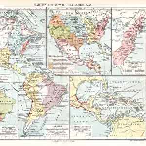
Premium Framed Print : Map of Brazil, 1749 (colour engraving)
")
")


![]()
Framed Photos from Fine Art Finder
Map of Brazil, 1749 (colour engraving)
XCF280551 Map of Brazil, 1749 (colour engraving) by Portuguese School, (18th Century); Private Collection; (add.info.: showing the Portuguese and Spanish boundaries; ); Portuguese, out of copyright
Media ID 12787902
© www.bridgemanart.com
Colonies Colony Geographical Latin America Southern America
31"x27" (79x69cm) Premium Frame
FSC real wood frame with double mounted 24x20 print. Double mounted with white conservation mountboard. Frame moulding comprises stained composite natural wood veneers (Finger Jointed Pine) 39mm wide by 21mm thick. Archival quality Fujifilm CA photo paper mounted onto 1mm card. Overall outside dimensions are 31x27 inches (787x685mm). Rear features Framing tape to cover staples, 50mm Hanger plate, cork bumpers. Glazed with durable thick 2mm Acrylic to provide a virtually unbreakable glass-like finish. Acrylic Glass is far safer, more flexible and much lighter than typical mineral glass. Moreover, its higher translucency makes it a perfect carrier for photo prints. Acrylic allows a little more light to penetrate the surface than conventional glass and absorbs UV rays so that the image and the picture quality doesn't suffer under direct sunlight even after many years. Easily cleaned with a damp cloth. Please note that, to prevent the paper falling through the mount window and to prevent cropping of the original artwork, the visible print may be slightly smaller to allow the paper to be securely attached to the mount without any white edging showing and to match the aspect ratio of the original artwork.
FSC Real Wood Frame and Double Mounted with White Conservation Mountboard - Professionally Made and Ready to Hang
Estimated Image Size (if not cropped) is 54.4cm x 59.9cm (21.4" x 23.6")
Estimated Product Size is 68.5cm x 78.7cm (27" x 31")
These are individually made so all sizes are approximate
Artwork printed orientated as per the preview above, with portrait (vertical) orientation to match the source image.
FEATURES IN THESE COLLECTIONS
> Fine Art Finder
> Maps (celestial & Terrestrial)
> Fine Art Finder
> Schools
> Portuguese School
EDITORS COMMENTS
This print showcases a remarkable piece of history - the "Map of Brazil, 1749". Created by the Portuguese School in the 18th century, this color engraving offers a fascinating glimpse into the geographical and political landscape of Brazil during that time. The map depicts not only the boundaries of both Portugal and Spain but also provides valuable insights into their colonial territories within South America. With intricate details and precise cartography, it serves as an invaluable resource for understanding the region's historical significance. As we delve into this visual masterpiece, we are transported back to an era when exploration and colonization were shaping Latin America. The artistry behind this map is evident in its vibrant colors and meticulous attention to detail. It captures our imagination with its portrayal of vast landscapes, rivers snaking through dense forests, and mountains rising majestically against clear skies. This particular print from Fine Art Finder allows us to appreciate every nuance of this historic artifact. Its inclusion in a private collection further emphasizes its rarity and importance. As we explore this image, let us marvel at how far we have come since those early days while acknowledging the rich cultural heritage that has shaped modern-day Brazil. Whether you are a geography enthusiast or simply captivated by South American history, this print invites you on a journey through time – where past meets present through artful cartography.
MADE IN THE UK
Safe Shipping with 30 Day Money Back Guarantee
FREE PERSONALISATION*
We are proud to offer a range of customisation features including Personalised Captions, Color Filters and Picture Zoom Tools
SECURE PAYMENTS
We happily accept a wide range of payment options so you can pay for the things you need in the way that is most convenient for you
* Options may vary by product and licensing agreement. Zoomed Pictures can be adjusted in the Basket.