Premium Framed Print > Arts > Artists > J > Thomas Jefferys
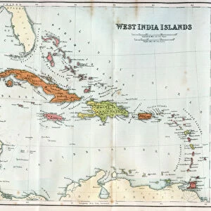
Premium Framed Print : Geography Atlas: representation of the Bahamas islands, northern Hispaniola (Santo Domingo) and the Leewind Passage between Cuba and Hispaniola in the West Indies
 and the Leewind Passage between Cuba and Hispaniola in the West Indies")
 and the Leewind Passage between Cuba and Hispaniola in the West Indies")


![]()
Framed Photos From Fine Art Finder
Geography Atlas: representation of the Bahamas islands, northern Hispaniola (Santo Domingo) and the Leewind Passage between Cuba and Hispaniola in the West Indies
VEN5029631 Geography Atlas: representation of the Bahamas islands, northern Hispaniola (Santo Domingo) and the Leewind Passage between Cuba and Hispaniola in the West Indies. Map taken from "The west indian atlas or general description of west indies" by Thomas Jefferys, geographer of the Prince of Wales, 1794. Biblioteca Jose Marti, Havana, Cuba.; (add.info.: Geography Atlas: representation of the Bahamas islands, northern Hispaniola (Santo Domingo) and the Leewind Passage between Cuba and Hispaniola in the West Indies. Map taken from "The west indian atlas or general description of west indies" by Thomas Jefferys, geographer of the Prince of Wales, 1794. Biblioteca Jose Marti, Havana, Cuba.); © Marage Photos
Media ID 38349062
© © Marage Photos / Bridgeman Images
Amerique Centrale Amerique Du Nord Caraïbes Caribbean Caribbean Island Carribean Carte Geographique Central America Cuba Cuba Cubain Cubaine Cubains Cubaines Cuban Dominium Etats Unis Geographie Saint Domingue Stockravenna 18eme Siecle Geographical Map
23"x19" (58x48cm) Premium Frame
FSC real wood frame with double mounted 16x12 print. Double mounted with white conservation mountboard. Frame moulding comprises stained composite natural wood veneers (Finger Jointed Pine) 39mm wide by 21mm thick. Archival quality Fujifilm CA photo paper mounted onto 1mm card. Overall outside dimensions are 23x19 inches (584x482mm). Rear features Framing tape to cover staples, 50mm Hanger plate, cork bumpers. Glazed with durable thick 2mm Acrylic to provide a virtually unbreakable glass-like finish. Acrylic Glass is far safer, more flexible and much lighter than typical mineral glass. Moreover, its higher translucency makes it a perfect carrier for photo prints. Acrylic allows a little more light to penetrate the surface than conventional glass and absorbs UV rays so that the image and the picture quality doesn't suffer under direct sunlight even after many years. Easily cleaned with a damp cloth. Please note that, to prevent the paper falling through the mount window and to prevent cropping of the original artwork, the visible print may be slightly smaller to allow the paper to be securely attached to the mount without any white edging showing and to match the aspect ratio of the original artwork.
FSC Real Wood Frame and Double Mounted with White Conservation Mountboard - Professionally Made and Ready to Hang
Estimated Image Size (if not cropped) is 39.6cm x 26.4cm (15.6" x 10.4")
Estimated Product Size is 58.4cm x 48.2cm (23" x 19")
These are individually made so all sizes are approximate
Artwork printed orientated as per the preview above, with landscape (horizontal) orientation to match the source image.
FEATURES IN THESE COLLECTIONS
> Fine Art Finder
> Artists
> Frank Reynolds
> Arts
> Artists
> J
> Thomas Jefferys
> Arts
> Artists
> N
> Thomas North
> Europe
> United Kingdom
> Wales
> Maps
> Europe
> United Kingdom
> Wales
> Posters
> Europe
> United Kingdom
> Wales
> Related Images
> Maps and Charts
> Early Maps
> Maps and Charts
> Related Images
> Maps and Charts
> Wales
> North America
> The Bahamas
> Maps
EDITORS COMMENTS
This stunning print captures a detailed representation of the Bahamas islands, northern Hispaniola (Santo Domingo), and the Leewind Passage between Cuba and Hispaniola in the West Indies. The map is taken from "The West Indian Atlas or General Description of West Indies" by Thomas Jefferys, geographer of the Prince of Wales, dating back to 1794.
The intricate engraving showcases the beauty and complexity of these Caribbean islands during the 18th century. The map provides a glimpse into the geographical features and topography of this region, offering valuable insights into navigation and exploration during that era.
Displayed in Biblioteca Jose Marti in Havana, Cuba, this historical artifact serves as a reminder of our rich maritime history and cultural heritage. It highlights the importance of cartography in understanding our world and its diverse landscapes.
As we admire this piece from Marage Photos captured by Bridgeman Images, we are transported back in time to an era when discovery and adventure shaped our understanding of geography. This print is not just a visual masterpiece but also a testament to human curiosity and ingenuity in mapping out unknown territories.
MADE IN THE UK
Safe Shipping with 30 Day Money Back Guarantee
FREE PERSONALISATION*
We are proud to offer a range of customisation features including Personalised Captions, Color Filters and Picture Zoom Tools
SECURE PAYMENTS
We happily accept a wide range of payment options so you can pay for the things you need in the way that is most convenient for you
* Options may vary by product and licensing agreement. Zoomed Pictures can be adjusted in the Basket.