Premium Framed Print > Europe > France > Maps
Premium Framed Print : Map of Cherbourg, France (engraving)
")
")


![]()
Framed Photos From Fine Art Finder
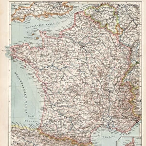
Map of Cherbourg, France (engraving)
8676462 Map of Cherbourg, France (engraving) by English School, (19th century); Private Collection; (add.info.: Map of Cherbourg, France, showing the harbour, docks and fortifications. Illustration from The Illustrated News of the World, 14 August 1858.); © Look and Learn
Media ID 38488722
© © Look and Learn / Bridgeman Images
Boat Dock Cherbourg Coast Line Dock Harbor Area Harbour Area Harbours Harbourside Pier Pontoons Quay Quayside Shorelines Wharf Marines Maritime Force Naval Force Naval Infantry Seawater
17"x15" (43x38cm) Premium Frame
FSC real wood frame with double mounted 10x8 print. Double mounted with white conservation mountboard. Frame moulding comprises stained composite natural wood veneers (Finger Jointed Pine) 39mm wide by 21mm thick. Archival quality Fujifilm CA photo paper mounted onto 1mm card. Overall outside dimensions are 17x15 inches (431x381mm). Rear features Framing tape to cover staples, 50mm Hanger plate, cork bumpers. Glazed with durable thick 2mm Acrylic to provide a virtually unbreakable glass-like finish. Acrylic Glass is far safer, more flexible and much lighter than typical mineral glass. Moreover, its higher translucency makes it a perfect carrier for photo prints. Acrylic allows a little more light to penetrate the surface than conventional glass and absorbs UV rays so that the image and the picture quality doesn't suffer under direct sunlight even after many years. Easily cleaned with a damp cloth. Please note that, to prevent the paper falling through the mount window and to prevent cropping of the original artwork, the visible print may be slightly smaller to allow the paper to be securely attached to the mount without any white edging showing and to match the aspect ratio of the original artwork.
FSC Real Wood Frame and Double Mounted with White Conservation Mountboard - Professionally Made and Ready to Hang
Estimated Image Size (if not cropped) is 21.3cm x 24.4cm (8.4" x 9.6")
Estimated Product Size is 38.1cm x 43.1cm (15" x 17")
These are individually made so all sizes are approximate
Artwork printed orientated as per the preview above, with portrait (vertical) orientation to match the source image.
FEATURES IN THESE COLLECTIONS
> Fine Art Finder
> Artists
> English School
> Maps and Charts
> Early Maps
> Maps and Charts
> Related Images
> Maps and Charts
> World
> Services
> Royal Navy
EDITORS COMMENTS
This stunning engraving of a Map of Cherbourg, France from the 19th century captures the intricate details of this historic port city. The illustration showcases the bustling harbor, docks, and fortifications that played a crucial role in maritime trade and naval operations during this time period.
The fine lines and intricate shading in the engraving highlight the precision and skill of the artist who created this detailed map. Each building, pier, and quayside is meticulously rendered, giving viewers a glimpse into life in Cherbourg during the 19th century.
Cherbourg's strategic location on the coast of France made it an important hub for shipping and naval activities. The map provides a fascinating look at how the city was laid out and organized to accommodate these functions.
As you study this engraving, you can almost imagine ships coming in and out of the harbor, unloading their cargo or setting sail for distant shores. It is a snapshot of history frozen in time, allowing us to appreciate both the beauty and functionality of Cherbourg as it existed centuries ago.
Whether you are a history buff or simply appreciate fine artistry, this Map of Cherbourg is sure to captivate your imagination with its rich detail and historical significance.
MADE IN THE UK
Safe Shipping with 30 Day Money Back Guarantee
FREE PERSONALISATION*
We are proud to offer a range of customisation features including Personalised Captions, Color Filters and Picture Zoom Tools
SECURE PAYMENTS
We happily accept a wide range of payment options so you can pay for the things you need in the way that is most convenient for you
* Options may vary by product and licensing agreement. Zoomed Pictures can be adjusted in the Basket.