Premium Framed Print > Maps and Charts > Early Maps
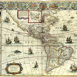
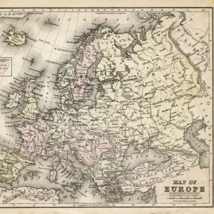
Premium Framed Print : A 1930s Map Of Europe


![]()
Framed Photos from Design Pics
A 1930s Map Of Europe
Design Pics offers Distinctively Different Imagery representing over 1,500 contributors
Media ID 18176902
© Hilary Jane Morgan / Design Pics
1930s 20th Countries Geographical Geography Nineteen Thirties Twentieth
23"x19" (58x48cm) Premium Frame
FSC real wood frame with double mounted 16x12 print. Double mounted with white conservation mountboard. Frame moulding comprises stained composite natural wood veneers (Finger Jointed Pine) 39mm wide by 21mm thick. Archival quality Fujifilm CA photo paper mounted onto 1mm card. Overall outside dimensions are 23x19 inches (584x482mm). Rear features Framing tape to cover staples, 50mm Hanger plate, cork bumpers. Glazed with durable thick 2mm Acrylic to provide a virtually unbreakable glass-like finish. Acrylic Glass is far safer, more flexible and much lighter than typical mineral glass. Moreover, its higher translucency makes it a perfect carrier for photo prints. Acrylic allows a little more light to penetrate the surface than conventional glass and absorbs UV rays so that the image and the picture quality doesn't suffer under direct sunlight even after many years. Easily cleaned with a damp cloth. Please note that, to prevent the paper falling through the mount window and to prevent cropping of the original artwork, the visible print may be slightly smaller to allow the paper to be securely attached to the mount without any white edging showing and to match the aspect ratio of the original artwork.
FSC Real Wood Frame and Double Mounted with White Conservation Mountboard - Professionally Made and Ready to Hang
Estimated Image Size (if not cropped) is 39.6cm x 25.4cm (15.6" x 10")
Estimated Product Size is 58.4cm x 48.2cm (23" x 19")
These are individually made so all sizes are approximate
Artwork printed orientated as per the preview above, with landscape (horizontal) orientation to match the source image.
FEATURES IN THESE COLLECTIONS
> Design Pics
> Design Pics Art
> Art llustrations and Engravings
> Maps and Charts
> Early Maps
> Maps and Charts
> Related Images
EDITORS COMMENTS
This print showcases a remarkable piece of history - a 1930s map of Europe meticulously crafted by the talented Hilary Jane Morgan. With its intricate details and vintage charm, this illustration takes us back to the early 20th century, offering a glimpse into European geography during that era. As we gaze upon this historical gem, our eyes are immediately drawn to the various countries that make up the continent. Each border is delicately outlined, highlighting the diverse nations that existed at that time. From bustling cities to serene countryside landscapes, this map captures Europe's rich tapestry of cultures and traditions. The artist's attention to detail is truly commendable; every river, mountain range, and coastline has been intricately depicted with precision. This stunning visual representation not only serves as an educational tool but also evokes nostalgia for a bygone era when borders were different and geopolitical dynamics were rapidly evolving. Whether you're an avid historian or simply appreciate artistry in its purest form, this 1930s Map of Europe will undoubtedly captivate your imagination. Hang it on your wall or display it proudly in your study – let it transport you back in time while igniting curiosity about how our world has transformed over the decades. Hilary Jane Morgan's masterpiece reminds us of the power maps hold in telling stories about our past and shaping our understanding of the present.
MADE IN THE UK
Safe Shipping with 30 Day Money Back Guarantee
FREE PERSONALISATION*
We are proud to offer a range of customisation features including Personalised Captions, Color Filters and Picture Zoom Tools
SECURE PAYMENTS
We happily accept a wide range of payment options so you can pay for the things you need in the way that is most convenient for you
* Options may vary by product and licensing agreement. Zoomed Pictures can be adjusted in the Basket.