Poster Print > Universal Images Group (UIG) > Universal Images Group > Satellite and Aerial > Planet Observer 5
Poster Print : Departement of Lot, France, Relief Map


![]()
Poster Prints from Universal Images Group (UIG)
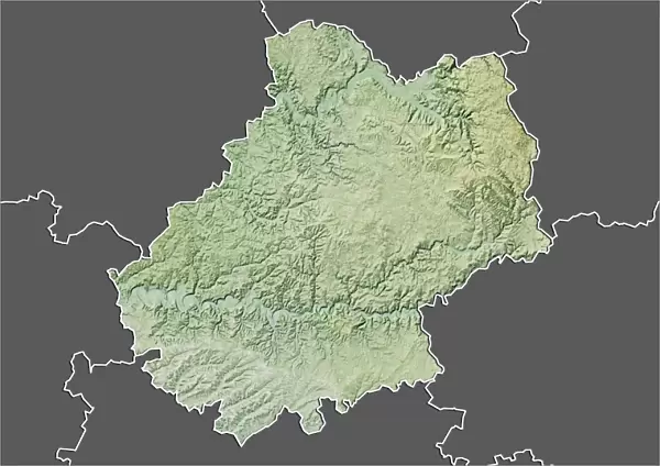
Departement of Lot, France, Relief Map
Relief map of the departement of Lot, France. This image was compiled from data acquired by LANDSAT 5 & 7 satellites combined with elevation data
Universal Images Group (UIG) manages distribution for many leading specialist agencies worldwide
Media ID 9633913
© Planet Observer
Geographical Border Midi Pyrenees Relief Map Satellite View
A2 (59.4 x 42cm) Poster Print
Discover the beauty of the French landscape with our Media Storehouse Poster Prints. This captivating image showcases a relief map of the Département of Lot, France, meticulously compiled from data acquired by LANDSAT 5 & 7 satellites, and enhanced with elevation data. Bring the intricacies of this historic region into your home or office, and let the rich topography tell its story. Order now and immerse yourself in the natural wonders of France.
A2 Poster (59.4 x 42cm, 23.4" x 16.5" inches) printed on 170gsm Satin Poster Paper. Securely packaged, rolled and inserted into a strong mailing tube and shipped tracked. Poster Prints are of comparable archival quality to our Photographic prints, they are simply printed on thinner Poster Paper. Whilst we only use Photographic Prints in our frames, you can frame Poster Prints if they are carefully supported to prevent sagging over time.
Poster prints are budget friendly enlarged prints in standard poster paper sizes (A0, A1, A2, A3 etc). Whilst poster paper is sometimes thinner and less durable than our other paper types, they are still ok for framing and should last many years. Our Archival Quality Photo Prints and Fine Art Paper Prints are printed on higher quality paper and the choice of which largely depends on your budget.
Estimated Product Size is 59.4cm x 42cm (23.4" x 16.5")
These are individually made so all sizes are approximate
Artwork printed orientated as per the preview above, with landscape (horizontal) orientation to match the source image.
EDITORS COMMENTS
This print showcases the stunning relief map of the Departement of Lot, France. A masterpiece compiled from data acquired by LANDSAT 5 & 7 satellites combined with elevation data, this image offers a unique perspective on the topography of this picturesque region. The vibrant colors and intricate details bring to life the geographical borders and physical features that define Lot. As we delve into this horizontal composition, our eyes are drawn to the mesmerizing contours and undulating landscapes that make up this part of Europe. The satellite view allows us to appreciate every nook and cranny, unveiling hidden valleys, rolling hills, and majestic peaks within Midi Pyrenees. Cartography enthusiasts will find themselves immersed in an exploration of Lot's diverse terrain as they trace rivers snaking their way through lush forests or marvel at expansive plateaus stretching towards distant horizons. This color image is a testament to both nature's grandeur and mankind's technological advancements in capturing its beauty. With no people present in the frame, one can fully immerse themselves in studying every minute detail etched onto this relief map. Whether you're an avid traveler planning your next adventure or simply fascinated by geography, this print serves as a gateway into discovering Lot's natural wonders from afar.
MADE IN THE UK
Safe Shipping with 30 Day Money Back Guarantee
FREE PERSONALISATION*
We are proud to offer a range of customisation features including Personalised Captions, Color Filters and Picture Zoom Tools
SECURE PAYMENTS
We happily accept a wide range of payment options so you can pay for the things you need in the way that is most convenient for you
* Options may vary by product and licensing agreement. Zoomed Pictures can be adjusted in the Basket.