Poster Print > Europe > Italy > Tuscany > Florence
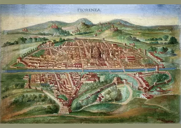
Poster Print : 16th Century Plan of Florence


![]()
Poster Prints from Science Photo Library
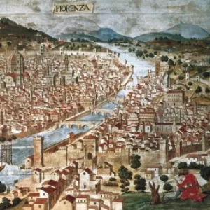
16th Century Plan of Florence
16th century plan of Florence, Italy. Detail from the map of Etruria (Tuscany and Northern Lazio), in the Gallery of Maps in the Vatican Museum.The Gallery of Maps holds maps which were commissioned between 1578 and 1580 to show the regions of Italy and territories of the church. The maps are based on the work of Ignazio Danti, a 16th century Italian priest, mathematician, astronomer and cosmographer, and are an important record of 16th century geography. Vatican Museum
Science Photo Library features Science and Medical images including photos and illustrations
Media ID 6321643
© Sheila Terry
1500s 16th Century Atlas Cartography Earth Science Florence Gallery Of Maps Ignazio Danti Italian Italy Mapping Maps Plan Sciences Sixteenth Century Etruria
A2 (59.4 x 42cm) Poster Print
Introducing the Media Storehouse range of Poster Prints featuring the captivating 16th Century Plan of Florence by Science Photo Library. This exquisite map transports us back in time, offering a rare glimpse into the architectural wonders and urban layout of Florence during the Renaissance era. Commissioned for the Gallery of Maps in the Vatican Museum, this intricately detailed map showcases the historical significance of Florence in the 16th century. Bring the rich history and culture of this Italian city right into your home or office with our high-quality poster prints. Each print is meticulously produced using premium materials to ensure vibrant colors and long-lasting durability. Experience the beauty and intrigue of this historical masterpiece in a stylish and affordable way. Order yours today and let the story of Florence unfold in your space.
A2 Poster (59.4 x 42cm, 23.4" x 16.5" inches) printed on 170gsm Satin Poster Paper. Securely packaged, rolled and inserted into a strong mailing tube and shipped tracked. Poster Prints are of comparable archival quality to our Photographic prints, they are simply printed on thinner Poster Paper. Whilst we only use Photographic Prints in our frames, you can frame Poster Prints if they are carefully supported to prevent sagging over time.
Poster prints are budget friendly enlarged prints in standard poster paper sizes (A0, A1, A2, A3 etc). Whilst poster paper is sometimes thinner and less durable than our other paper types, they are still ok for framing and should last many years. Our Archival Quality Photo Prints and Fine Art Paper Prints are printed on higher quality paper and the choice of which largely depends on your budget.
Estimated Image Size (if not cropped) is 59.4cm x 39.1cm (23.4" x 15.4")
Estimated Product Size is 59.4cm x 42cm (23.4" x 16.5")
These are individually made so all sizes are approximate
Artwork printed orientated as per the preview above, with landscape (horizontal) orientation to match the source image.
FEATURES IN THESE COLLECTIONS
> Europe
> Italy
> Lazio
> Related Images
> Europe
> Italy
> Tuscany
> Florence
> Europe
> Italy
> Tuscany
> Related Images
> Maps and Charts
> Early Maps
> Maps and Charts
> Italy
> Maps and Charts
> Related Images
EDITORS COMMENTS
This print showcases a remarkable 16th-century plan of Florence, Italy. Extracted from the larger map of Etruria (Tuscany and Northern Lazio) housed in the prestigious Gallery of Maps at the Vatican Museum, this detail offers a glimpse into the rich history and geography of Renaissance-era Florence. Commissioned between 1578 and 1580, these maps were created to depict various regions of Italy as well as territories belonging to the Church. The mastermind behind these intricate cartographic works was Ignazio Danti, an esteemed Italian priest, mathematician, astronomer, and cosmographer. His expertise in multiple fields allowed him to craft accurate representations that serve as invaluable records of 16th-century geography. The significance of this particular print lies not only in its historical importance but also in its artistic beauty. The illustration transports viewers back to a time when Florentine culture flourished under Medici patronage and iconic landmarks like Brunelleschi's Dome dominated the cityscape. As we delve into this snapshot from Earth's past, we are reminded of how science intertwines with artistry through cartography. This mesmerizing image invites us to appreciate both the scientific advancements made during the Renaissance period and their visual representation on paper—a testament to human curiosity and ingenuity that continues to inspire us today.
MADE IN THE UK
Safe Shipping with 30 Day Money Back Guarantee
FREE PERSONALISATION*
We are proud to offer a range of customisation features including Personalised Captions, Color Filters and Picture Zoom Tools
SECURE PAYMENTS
We happily accept a wide range of payment options so you can pay for the things you need in the way that is most convenient for you
* Options may vary by product and licensing agreement. Zoomed Pictures can be adjusted in the Basket.