Poster Print > Europe > United Kingdom > England > Maps
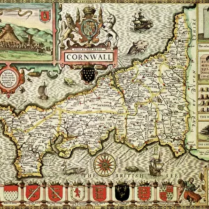
Poster Print : Map / Cornwall C1857


![]()
Poster Prints from Mary Evans Picture Library
Map / Cornwall C1857
Map of Cornwall Date: circa 1857
Mary Evans Picture Library makes available wonderful images created for people to enjoy over the centuries
Media ID 14291483
© Mary Evans Picture Library
A2 (59.4 x 42cm) Poster Print
Introducing the captivating Map / Cornwall C1857 poster print from Media Storehouse's exclusive collection. This magnificent piece, sourced from Mary Evans Prints Online, transports you back in time to the mid-1800s with its intricate and detailed depiction of Cornwall's landscape. With rights managed rights, this authentic map is not just a decorative addition to your space, but a window into history. Relive the charm of the past and bring a touch of nostalgia to your home or office with this stunning, vintage map poster print.
A2 Poster (59.4 x 42cm, 23.4" x 16.5" inches) printed on 170gsm Satin Poster Paper. Securely packaged, rolled and inserted into a strong mailing tube and shipped tracked. Poster Prints are of comparable archival quality to our Photographic prints, they are simply printed on thinner Poster Paper. Whilst we only use Photographic Prints in our frames, you can frame Poster Prints if they are carefully supported to prevent sagging over time.
Poster prints are budget friendly enlarged prints in standard poster paper sizes (A0, A1, A2, A3 etc). Whilst poster paper is sometimes thinner and less durable than our other paper types, they are still ok for framing and should last many years. Our Archival Quality Photo Prints and Fine Art Paper Prints are printed on higher quality paper and the choice of which largely depends on your budget.
Estimated Image Size (if not cropped) is 54cm x 42cm (21.3" x 16.5")
Estimated Product Size is 59.4cm x 42cm (23.4" x 16.5")
These are individually made so all sizes are approximate
Artwork printed orientated as per the preview above, with landscape (horizontal) orientation to match the source image.
FEATURES IN THESE COLLECTIONS
> Europe
> United Kingdom
> England
> Cornwall
> Related Images
> Europe
> United Kingdom
> England
> Maps
> Europe
> United Kingdom
> England
> Posters
> Europe
> United Kingdom
> England
> Related Images
> Maps and Charts
> Early Maps
> Maps and Charts
> Related Images
EDITORS COMMENTS
1. Title: "Exploring the Past: A Glimpse into Cornwall's History through a 1857 Map" This print showcases an intricately detailed map of Cornwall, England, dating back to circa 1857. The map, a testament to the cartographic skills of the time, offers a fascinating glimpse into the historical landscape of this beautiful region. Cornwall, located in the southwestern tip of England, has a rich and diverse history, shaped by its unique geography, natural resources, and cultural traditions. This map, produced around the mid-19th century, captures the county's topography, settlements, and transportation networks as they existed during that period. The map's meticulous illustration of the coastline reveals the numerous coves, bays, and harbors that have long made Cornwall a popular destination for mariners and tourists alike. The inland areas are equally well-represented, with the intricate depiction of villages, towns, and estates reflecting the social and economic fabric of the region. The transportation network, as shown on the map, provides valuable insights into the means of travel and communication during the Victorian era. The extensive rail and road networks, as well as the numerous ferry routes, attest to the growing importance of connectivity in an increasingly industrialized world. As we delve deeper into the map's details, we can also observe the presence of various historical sites and landmarks, such as ancient castles, monasteries, and mines. These relics of the past serve as reminders of Cornwall's rich cultural heritage and its significant role in the broader history of England. In summary, this 1857 map of Cornwall offers a captivating window into the past, providing us with a unique perspective on the region's history, geography, and cultural landscape. Whether you are an avid historian, a curious traveler, or simply someone who appreciates the beauty of historical maps, this print is sure to inspire wonder and intrigue.
MADE IN THE UK
Safe Shipping with 30 Day Money Back Guarantee
FREE PERSONALISATION*
We are proud to offer a range of customisation features including Personalised Captions, Color Filters and Picture Zoom Tools
SECURE PAYMENTS
We happily accept a wide range of payment options so you can pay for the things you need in the way that is most convenient for you
* Options may vary by product and licensing agreement. Zoomed Pictures can be adjusted in the Basket.