Poster Print > Maps and Charts > Early Maps
Poster Print : Description de la Terre Universelle (1667). Map
. Map")


![]()
Poster Prints from Mary Evans Picture Library
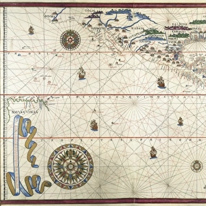
Description de la Terre Universelle (1667). Map
Description de la Terre Universelle (1667). Map. Engraving
Mary Evans Picture Library makes available wonderful images created for people to enjoy over the centuries
Media ID 8272173
© Mary Evans Picture Library 2015 - https://copyrighthub.org/s0/hub1/creation/maryevans/MaryEvansPictureID/10685826
Alpha Cartographic Cartographies Cartography Description Earth Engravings Equator Equatorial Maps Navigation Omega Sail Terre Terrestrial Universelle
A2 (59.4 x 42cm) Poster Print
Introducing the captivating collection of poster prints from Media Storehouse, featuring the exquisite "Description de la Terre Universelle (1667). Map" by Rights Managed from Mary Evans Prints Online. This enchanting antique map, created in 1667, offers a mesmerizing glimpse into the world as it was once perceived. With intricate detail and vivid colors, this map transports you back in time, inviting you to explore the wonders of the known world over three centuries ago. Each print is meticulously produced using high-quality materials and state-of-the-art printing techniques to bring out the rich details and colors of this historical masterpiece. Add an air of sophistication and intrigue to any space with these stunning poster prints, perfect for the home office, study, or as a conversation starter in your living room. Embrace the past and embark on a captivating journey with Media Storehouse's range of poster prints.
A2 Poster (59.4 x 42cm, 23.4" x 16.5" inches) printed on 170gsm Satin Poster Paper. Securely packaged, rolled and inserted into a strong mailing tube and shipped tracked. Poster Prints are of comparable archival quality to our Photographic prints, they are simply printed on thinner Poster Paper. Whilst we only use Photographic Prints in our frames, you can frame Poster Prints if they are carefully supported to prevent sagging over time.
Poster prints are budget friendly enlarged prints in standard poster paper sizes (A0, A1, A2, A3 etc). Whilst poster paper is sometimes thinner and less durable than our other paper types, they are still ok for framing and should last many years. Our Archival Quality Photo Prints and Fine Art Paper Prints are printed on higher quality paper and the choice of which largely depends on your budget.
Estimated Product Size is 59.4cm x 42cm (23.4" x 16.5")
These are individually made so all sizes are approximate
Artwork printed orientated as per the preview above, with landscape (horizontal) orientation to match the source image.
FEATURES IN THESE COLLECTIONS
> Maps and Charts
> Early Maps
> Maps and Charts
> Related Images
EDITORS COMMENTS
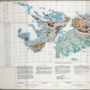
This stunning engraving is a captivating glimpse into the historical world of cartography during the 17th century. The "Description de la Terre Universelle" or "Description of the Universal Earth," created in 1667, is a remarkable example of early terrestrial mapping. The map's title, written in elegant script, is situated at the top, with the equator and meridian lines clearly marked, dividing the map into quadrants. The map's horizontal orientation, a departure from the traditional vertical format, reflects the growing influence of the nautical community in cartography. The map's intricate detailing showcases the known world as it was understood during that time, with accurate depictions of continents, islands, and major bodies of water. The map's color palette, while not vibrant by today's standards, would have been a significant improvement over the monochrome maps of the past. The map's border is adorned with various decorative elements, including intricate engravings of sailing ships and the Greek letters Alpha and Omega, symbolizing the beginning and end of the world. The map's creation was a testament to the advancements in navigation and cartography during the Age of Exploration. It served as a valuable tool for navigators and explorers, helping them to chart their courses and expand the boundaries of human knowledge. Today, this engraving stands as a reminder of the rich history of cartography and the enduring allure of the world's vast and mysterious landscapes.
MADE IN THE UK
Safe Shipping with 30 Day Money Back Guarantee
FREE PERSONALISATION*
We are proud to offer a range of customisation features including Personalised Captions, Color Filters and Picture Zoom Tools
SECURE PAYMENTS
We happily accept a wide range of payment options so you can pay for the things you need in the way that is most convenient for you
* Options may vary by product and licensing agreement. Zoomed Pictures can be adjusted in the Basket.