Poster Print > Maps and Charts > British Empire Maps
Poster Print : British Empire Map 1902


![]()
Poster Prints from Mary Evans Picture Library
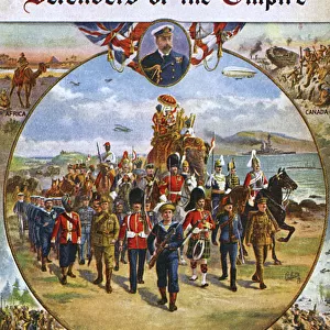
British Empire Map 1902
Map showing the extent of the British Empire in 1902 - the Empire on which the sun never sets
Mary Evans Picture Library makes available wonderful images created for people to enjoy over the centuries
Media ID 4322812
© Mary Evans Picture Library 2015 - https://copyrighthub.org/s0/hub1/creation/maryevans/MaryEvansPictureID/10025389
A2 (59.4 x 42cm) Poster Print
"Step back in time with our exquisite British Empire Map 1902 print from Media Storehouse. This captivating poster, sourced from Mary Evans Prints Online, showcases the extensive reach of the British Empire at the turn of the 20th century. A testament to the historical significance of this period, this Rights Managed image is sure to make a striking addition to any wall. Bring a touch of history into your home or office and relive the stories of the 'Empire on which the sun never sets'."
A2 Poster (59.4 x 42cm, 23.4" x 16.5" inches) printed on 170gsm Satin Poster Paper. Securely packaged, rolled and inserted into a strong mailing tube and shipped tracked. Poster Prints are of comparable archival quality to our Photographic prints, they are simply printed on thinner Poster Paper. Whilst we only use Photographic Prints in our frames, you can frame Poster Prints if they are carefully supported to prevent sagging over time.
Poster prints are budget friendly enlarged prints in standard poster paper sizes (A0, A1, A2, A3 etc). Whilst poster paper is sometimes thinner and less durable than our other paper types, they are still ok for framing and should last many years. Our Archival Quality Photo Prints and Fine Art Paper Prints are printed on higher quality paper and the choice of which largely depends on your budget.
Estimated Product Size is 42cm x 59.4cm (16.5" x 23.4")
These are individually made so all sizes are approximate
Artwork printed orientated as per the preview above, with portrait (vertical) orientation to match the source image.
FEATURES IN THESE COLLECTIONS
> Maps and Charts
> British Empire Maps
> Maps and Charts
> Early Maps
> Maps and Charts
> Related Images
EDITORS COMMENTS
This striking print of the British Empire Map from 1902 showcases the vast extent of one of history's most powerful empires. The map illustrates the reach of British imperialism at its peak, with territories spanning across continents and oceans. Known as the empire on which the sun never sets, this map is a visual representation of Britain's dominance and influence during this time.
The intricate details on the map provide a glimpse into the historical significance and political power that characterized the British Empire in 1902. From India to Africa to Australia, each region under British rule is clearly demarcated, highlighting the sheer magnitude of their global presence.
As we reflect on this piece of history, it serves as a reminder of both the achievements and controversies associated with imperialism. The legacy left behind by the British Empire continues to shape geopolitics and international relations to this day.
Whether you are a history enthusiast or simply appreciate fine art, this print offers a unique perspective on a pivotal moment in world history. Displaying it in your home or office will not only add an element of sophistication but also spark conversations about colonialism, power dynamics, and cultural exchange.
MADE IN THE UK
Safe Shipping with 30 Day Money Back Guarantee
FREE PERSONALISATION*
We are proud to offer a range of customisation features including Personalised Captions, Color Filters and Picture Zoom Tools
SECURE PAYMENTS
We happily accept a wide range of payment options so you can pay for the things you need in the way that is most convenient for you
* Options may vary by product and licensing agreement. Zoomed Pictures can be adjusted in the Basket.