Jigsaw Puzzle > Maps and Charts > British Empire Maps
Jigsaw Puzzle : British Empire Map 1902


![]()
Jigsaw Puzzles from Mary Evans Picture Library
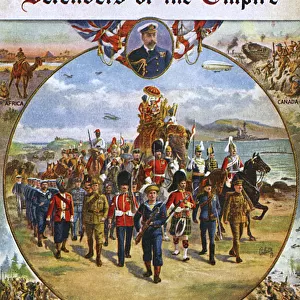
British Empire Map 1902
Map showing the extent of the British Empire in 1902 - the Empire on which the sun never sets
Mary Evans Picture Library makes available wonderful images created for people to enjoy over the centuries
Media ID 4322812
© Mary Evans Picture Library 2015 - https://copyrighthub.org/s0/hub1/creation/maryevans/MaryEvansPictureID/10025389
Jigsaw Puzzle (400 Pieces)
Discover the rich history of the British Empire with our captivating jigsaw puzzle from Media Storehouse. This intricately detailed puzzle, featuring a vintage British Empire Map from 1902 obtained from Mary Evans Prints Online, presents an engaging challenge for puzzle enthusiasts. Immerse yourself in the intricacies of the map, tracing the vast expanse of the Empire that once spanned the globe. Perfect for history buffs, geography enthusiasts, or anyone seeking a brain-teasing activity, this puzzle is a beautiful addition to any home or office. Engage in a journey of discovery, piece by piece, as you bring back to life the Empire on which the sun never sets.
400 piece puzzles are custom made in the UK and hand-finished on 100% recycled 1.5 mm millboard. There is a level of repetition in jigsaw shapes with each matching piece away from its pair. The completed puzzle measures 31x47cm and is delivered packaged in an attractive presentation box specially designed to fit most letter box slots
Jigsaw Puzzles are an ideal gift for any occasion
Estimated Product Size is 31.5cm x 47.2cm (12.4" x 18.6")
These are individually made so all sizes are approximate
Artwork printed orientated as per the preview above, with landscape (horizontal) or portrait (vertical) orientation to match the source image.
FEATURES IN THESE COLLECTIONS
> Maps and Charts
> British Empire Maps
> Maps and Charts
> Early Maps
> Maps and Charts
> Related Images
EDITORS COMMENTS
This striking print of the British Empire Map from 1902 showcases the vast extent of one of history's most powerful empires. The map illustrates the reach of British imperialism at its peak, with territories spanning across continents and oceans. Known as the empire on which the sun never sets, this map is a visual representation of Britain's dominance and influence during this time.
The intricate details on the map provide a glimpse into the historical significance and political power that characterized the British Empire in 1902. From India to Africa to Australia, each region under British rule is clearly demarcated, highlighting the sheer magnitude of their global presence.
As we reflect on this piece of history, it serves as a reminder of both the achievements and controversies associated with imperialism. The legacy left behind by the British Empire continues to shape geopolitics and international relations to this day.
Whether you are a history enthusiast or simply appreciate fine art, this print offers a unique perspective on a pivotal moment in world history. Displaying it in your home or office will not only add an element of sophistication but also spark conversations about colonialism, power dynamics, and cultural exchange.
MADE IN THE UK
Safe Shipping with 30 Day Money Back Guarantee
FREE PERSONALISATION*
We are proud to offer a range of customisation features including Personalised Captions, Color Filters and Picture Zoom Tools
SECURE PAYMENTS
We happily accept a wide range of payment options so you can pay for the things you need in the way that is most convenient for you
* Options may vary by product and licensing agreement. Zoomed Pictures can be adjusted in the Basket.