Poster Print > Europe > France > Canton > Landes
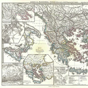
Poster Print : 1794, Delisle Map of Southern Ancient Greece, Greeks Isles, and Crete, topography


![]()
Poster Prints from Liszt Collection
1794, Delisle Map of Southern Ancient Greece, Greeks Isles, and Crete, topography
1794, Delisle Map of Southern Ancient Greece, Greeks Isles, and Crete
Liszt Collection of nineteenth-century engravings and images to browse and enjoy
Media ID 14004831
© Artokoloro Quint Lox Limited
1794 Antique Map Latitude Longitude Mappa Mundi Old Antique Plan Old Antique View Ols Antique Map Rare Old Maps Topo
A2 (59.4 x 42cm) Poster Print
Discover the rich history and intricate detail of ancient Greece with our stunning Media Storehouse Poster Print of the 1794 Delisle Map. This exquisite map, part of the esteemed Liszt Collection, provides a captivating glimpse into the topography of Southern Ancient Greece, the Greeks Isles, and Crete as it was understood during the late 18th century. With its meticulous cartography, this poster print makes an excellent addition to any home or office space, inspiring awe and knowledge in all who behold it. Travel back in time and embark on a journey through the ancient world with this beautiful and historic poster print.
A2 Poster (59.4 x 42cm, 23.4" x 16.5" inches) printed on 170gsm Satin Poster Paper. Securely packaged, rolled and inserted into a strong mailing tube and shipped tracked. Poster Prints are of comparable archival quality to our Photographic prints, they are simply printed on thinner Poster Paper. Whilst we only use Photographic Prints in our frames, you can frame Poster Prints if they are carefully supported to prevent sagging over time.
Poster prints are budget friendly enlarged prints in standard poster paper sizes (A0, A1, A2, A3 etc). Whilst poster paper is sometimes thinner and less durable than our other paper types, they are still ok for framing and should last many years. Our Archival Quality Photo Prints and Fine Art Paper Prints are printed on higher quality paper and the choice of which largely depends on your budget.
Estimated Image Size (if not cropped) is 56cm x 42cm (22" x 16.5")
Estimated Product Size is 59.4cm x 42cm (23.4" x 16.5")
These are individually made so all sizes are approximate
Artwork printed orientated as per the preview above, with landscape (horizontal) orientation to match the source image.
FEATURES IN THESE COLLECTIONS
> Europe
> France
> Canton
> Landes
> Europe
> Greece
> Related Images
> Historic
> Ancient civilizations
> Ancient Greece
> Greek history
> Historic
> Space exploration
> Maps and Charts
> Early Maps
> Maps and Charts
> Related Images
> Maps and Charts
> World
EDITORS COMMENTS
This print showcases the exquisite 1794 Delisle Map of Southern Ancient Greece, Greek Isles, and Crete. A true masterpiece of cartography, this topographical map provides a detailed illustration of the region's geography and landforms. Its precise grid system based on latitude and longitude adds a touch of geometric elegance to its overall design. A vintage treasure steeped in history, this ancient map takes us on a visual journey through time. It offers an invaluable glimpse into the past, allowing us to explore the world as it was centuries ago. The delicate artistry and intricate details make it not just a navigational tool but also a decorative piece that exudes charm. Printed on aged paper with retro aesthetics, this rare antique map evokes a sense of nostalgia for bygone eras when exploration and discovery were at their peak. It serves as both an educational resource for historians and geographers alike while also serving as an artistic representation of Earth's diverse regions. The Liszt Collection has preserved this remarkable piece from oblivion so that we may appreciate its historical significance today. This print is more than just an old antique view; it is a mappa mundi that connects us to our past while reminding us of the vastness and beauty of our world.
MADE IN THE UK
Safe Shipping with 30 Day Money Back Guarantee
FREE PERSONALISATION*
We are proud to offer a range of customisation features including Personalised Captions, Color Filters and Picture Zoom Tools
SECURE PAYMENTS
We happily accept a wide range of payment options so you can pay for the things you need in the way that is most convenient for you
* Options may vary by product and licensing agreement. Zoomed Pictures can be adjusted in the Basket.