Poster Print > Europe > United Kingdom > Scotland > Dundee > Dundee
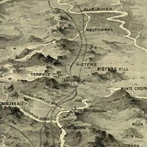
Poster Print : Map Illustrating General Bullers Campaign in Natal - May-June 1900, 1901. Creator: Unknown


![]()
Poster Prints from Heritage Images
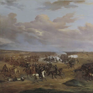
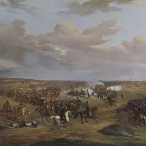
Map Illustrating General Bullers Campaign in Natal - May-June 1900, 1901. Creator: Unknown
Map Illustrating General Bullers Campaign in Natal - May-June 1900, 1901. From " South Africa and the Transvaal War, Vol. VI", by Louis Creswicke. [T. C. & E. C. Jack, Edinburgh, 1901]
Heritage Images features heritage image collections
Media ID 19781199
© The Print Collector/Heritage Images
1899 1902 2nd Boer War Bamp W Boer Wars Buller Campaign Colonel Redvers Buller Creswicke Dundee General Buller Jack June Kwazulu Natal Ladysmith Louis Louis Creswicke Military Campaign Month Newcastle Occupied Territory Province Of Kwazulu Natal Redvers Redvers Buller Redvers Henry Redvers Henry Buller Second Boer War Second Transvaal War Sir Redvers Sir Redvers Buller Sir Redvers Henry Buller South Africa South Africa And The Transvaal War South African Strategic Strategy Tc And Ec Tc And Ec Jack Territorial Territory Transvaal British Empire
A2 (59.4 x 42cm) Poster Print
Step back in time with our vintage Map Illustrating General Buller's Campaign in Natal from May-June 1900, 1901. This historical poster print, sourced from the pages of "South Africa and the Transvaal War, Vol. VI," showcases an intricately detailed map of the region, providing a unique insight into the strategic movements during the Second Boer War. Created from an original image in the Heritage Images archive, this captivating print is a must-have for history enthusiasts and collectors. With its rich, authentic details, this poster adds character and depth to any space, making it an excellent conversation starter. Unknown creator, but the map was published in Edinburgh, Scotland, by T. C. & E. C. Jack in 1901.
A2 Poster (59.4 x 42cm, 23.4" x 16.5" inches) printed on 170gsm Satin Poster Paper. Securely packaged, rolled and inserted into a strong mailing tube and shipped tracked. Poster Prints are of comparable archival quality to our Photographic prints, they are simply printed on thinner Poster Paper. Whilst we only use Photographic Prints in our frames, you can frame Poster Prints if they are carefully supported to prevent sagging over time.
Poster prints are budget friendly enlarged prints in standard poster paper sizes (A0, A1, A2, A3 etc). Whilst poster paper is sometimes thinner and less durable than our other paper types, they are still ok for framing and should last many years. Our Archival Quality Photo Prints and Fine Art Paper Prints are printed on higher quality paper and the choice of which largely depends on your budget.
Estimated Product Size is 42cm x 59.4cm (16.5" x 23.4")
These are individually made so all sizes are approximate
Artwork printed orientated as per the preview above, with portrait (vertical) orientation to match the source image.
FEATURES IN THESE COLLECTIONS
> Africa
> Related Images
> Africa
> South Africa
> Maps
> Africa
> South Africa
> Related Images
> Arts
> Literature
> Europe
> United Kingdom
> Northern Ireland
> County Down
> Newcastle
> Europe
> United Kingdom
> Scotland
> Dundee
> Dundee
> Europe
> United Kingdom
> Scotland
> Edinburgh
> Edinburgh
> Europe
> United Kingdom
> Scotland
> Lothian
> Edinburgh
> Maps and Charts
> British Empire Maps
EDITORS COMMENTS
This print showcases a historical map titled "Map Illustrating General Bullers Campaign in Natal - May-June 1900,1901". The creator of this remarkable piece remains unknown, but its significance cannot be understated. Taken from the book "South Africa and the Transvaal War, Vol. VI" by Louis Creswicke, published in Edinburgh in 1901, it offers a glimpse into the military strategy employed during the Second Boer War. The map depicts British General Sir Redvers Buller's campaign in Natal during May and June of 1900. It highlights key locations such as Newcastle, Dundee, Ladysmith, and Kwazulu Natal province. This strategic territory played a crucial role in Britain's colonial ambitions within South Africa at that time. As we delve into this image steeped with history and Victorian-era charm, we are transported to an era defined by conflict and territorial occupation. The intricate details on the map serve as a reminder of the complexity involved in military campaigns during this period. Through this print collector's treasure, we gain insight into not only the geographical aspects but also the political implications surrounding British imperialism and colonialism within South Africa. It serves as a valuable resource for scholars studying both military tactics and broader concepts such as power dynamics between nations. Let us cherish this snapshot from history that captures an essential chapter of South African heritage – one that shaped not only its past but also its future trajectory within the global landscape.
MADE IN THE UK
Safe Shipping with 30 Day Money Back Guarantee
FREE PERSONALISATION*
We are proud to offer a range of customisation features including Personalised Captions, Color Filters and Picture Zoom Tools
SECURE PAYMENTS
We happily accept a wide range of payment options so you can pay for the things you need in the way that is most convenient for you
* Options may vary by product and licensing agreement. Zoomed Pictures can be adjusted in the Basket.