Poster Print > Europe > United Kingdom > Wales > Maps
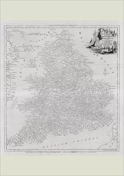
Poster Print : Map of the counties of England and Wales (engraving)
")


![]()
Poster Prints from Fine Art Finder
Map of the counties of England and Wales (engraving)
7147405 Map of the counties of England and Wales (engraving) by English School, (18th century); Private Collection; (add.info.: Map of the counties of England and Wales. Illustration from The New, Impartial and Complete History of England by Edward Barnard (Alex Hogg, c 1790).); © Look and Learn
Media ID 24756996
© Look and Learn / Bridgeman Images
City Map City Plan General Map North Of Wales North Wales South Wales Street Plan Welsh
A2 (59.4 x 42cm) Poster Print
Discover the rich history of England and Wales with our exquisite Map of the Counties print from Bridgeman Images. This stunning engraving, dating back to the 18th century, showcases an intricate and detailed representation of the counties of England and Wales. Add an air of sophistication and historical charm to your home or office with this beautiful fine art print from Media Storehouse's extensive collection at Fine Art Finder. A timeless piece for those who appreciate the beauty and history of cartography.
A2 Poster (59.4 x 42cm, 23.4" x 16.5" inches) printed on 170gsm Satin Poster Paper. Securely packaged, rolled and inserted into a strong mailing tube and shipped tracked. Poster Prints are of comparable archival quality to our Photographic prints, they are simply printed on thinner Poster Paper. Whilst we only use Photographic Prints in our frames, you can frame Poster Prints if they are carefully supported to prevent sagging over time.
Poster prints are budget friendly enlarged prints in standard poster paper sizes (A0, A1, A2, A3 etc). Whilst poster paper is sometimes thinner and less durable than our other paper types, they are still ok for framing and should last many years. Our Archival Quality Photo Prints and Fine Art Paper Prints are printed on higher quality paper and the choice of which largely depends on your budget.
Estimated Image Size (if not cropped) is 42cm x 45.8cm (16.5" x 18")
Estimated Product Size is 42cm x 59.4cm (16.5" x 23.4")
These are individually made so all sizes are approximate
Artwork printed orientated as per the preview above, with portrait (vertical) orientation to match the source image.
FEATURES IN THESE COLLECTIONS
> Fine Art Finder
> Artists
> English School
> Arts
> Portraits
> Pop art gallery
> Street art portraits
> Europe
> United Kingdom
> England
> Maps
> Europe
> United Kingdom
> Maps
> Europe
> United Kingdom
> Wales
> Maps
> Europe
> United Kingdom
> Wales
> Posters
> Europe
> United Kingdom
> Wales
> Related Images
> Maps and Charts
> Early Maps
> Maps and Charts
> Related Images
> Maps and Charts
> Wales
EDITORS COMMENTS
This print showcases a remarkable engraving of the Map of the counties of England and Wales, dating back to the 18th century. The intricate details and precision captured in this artwork are truly awe-inspiring. Created by an anonymous English School artist, this map is part of a private collection. The historical significance of this piece becomes even more apparent when we learn that it was originally featured in "The New, Impartial and Complete History of England" by Edward Barnard, published around 1790. Its inclusion in such a renowned publication speaks volumes about its accuracy and importance during that time. As we gaze upon this black-and-white illustration, we are transported back to a different era - one where England and Wales were united under one crown. It serves as a reminder of the rich history shared between these two nations. Not only does this map provide valuable geographical information about cities, towns, and counties within England and Wales, but it also offers insight into their cultural heritage. From bustling city plans to serene street layouts, every detail has been meticulously engraved with utmost care. Bridgeman Images has done an exceptional job preserving this piece for us to admire today through their fine art finder platform. This print allows us to appreciate the craftsmanship involved in creating such an exquisite map while immersing ourselves in the history it represents.
MADE IN THE UK
Safe Shipping with 30 Day Money Back Guarantee
FREE PERSONALISATION*
We are proud to offer a range of customisation features including Personalised Captions, Color Filters and Picture Zoom Tools
SECURE PAYMENTS
We happily accept a wide range of payment options so you can pay for the things you need in the way that is most convenient for you
* Options may vary by product and licensing agreement. Zoomed Pictures can be adjusted in the Basket.