Postcard > Universal Images Group (UIG) > Universal Images Group > Satellite and Aerial > Planet Observer 4
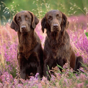
Postcard : Guinea, Relief Map With Border and Mask


![]()
Cards from Universal Images Group (UIG)
Guinea, Relief Map With Border and Mask
Relief map of Guinea (with border and mask). This image was compiled from data acquired by landsat 5 & 7 satellites combined with elevation data
Universal Images Group (UIG) manages distribution for many leading specialist agencies worldwide
Media ID 9613499
© Planet Observer/UIG
Africa Coastline Guinea Relief Map Shore Niger River Satellite View
Postcards (8 pack of A6)
Set of 8, A6 Postcards, featuring the same image on all cards in a set. Printed on 350gsm premium white satin card, the back of the postcard includes space to write messages and an area for the address and stamp. Size of each postcard is 15cm x 10.6cm.
Photo postcards are a great way to stay in touch with family and friends.
Estimated Product Size is 15cm x 10.6cm (5.9" x 4.2")
These are individually made so all sizes are approximate
Artwork printed orientated as per the preview above, with landscape (horizontal) or portrait (vertical) orientation to match the source image.
EDITORS COMMENTS
This print showcases the stunning relief map of Guinea, a country nestled in West Africa. With its intricate details and vibrant colors, this image offers a unique perspective on the physical geography of Guinea. Compiled from data acquired by landsat 5 & 7 satellites combined with elevation data, this map provides an accurate representation of the land's topography. The border and mask surrounding the relief map add an artistic touch to this photograph, enhancing its visual appeal. The coastline is beautifully depicted, highlighting Guinea's proximity to the Atlantic Ocean. The Niger River can also be seen meandering through the landscape, adding to the overall charm of this satellite view. With no people present in the image, it allows viewers to solely focus on appreciating Guinea's natural beauty and geographical features. Whether you are a cartography enthusiast or simply intrigued by African landscapes, this horizontal print will undoubtedly captivate your attention. Perfect for educational purposes or as a decorative piece in any space, this color image brings together art and science seamlessly. It invites us to explore Guinea's diverse terrain from afar while igniting our curiosity about what lies beyond its borders. This remarkable photograph truly celebrates both nature's wonders and human ingenuity in capturing them through satellite technology.
MADE IN THE UK
Safe Shipping with 30 Day Money Back Guarantee
FREE PERSONALISATION*
We are proud to offer a range of customisation features including Personalised Captions, Color Filters and Picture Zoom Tools
SECURE PAYMENTS
We happily accept a wide range of payment options so you can pay for the things you need in the way that is most convenient for you
* Options may vary by product and licensing agreement. Zoomed Pictures can be adjusted in the Basket.