Postcard > Europe > France > Paris > Maps
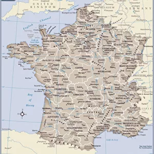
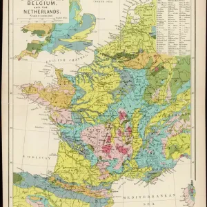
Postcard : MAP OF FRANCE, c1900. With inset detail of Paris and surrounding area


![]()
Cards from Granger
MAP OF FRANCE, c1900. With inset detail of Paris and surrounding area
Granger holds millions of images spanning more than 25,000 years of world history, from before the Stone Age to the dawn of the Space Age
Media ID 6622393
Postcards (8 pack of A6)
Set of 8, A6 Postcards, featuring the same image on all cards in a set. Printed on 350gsm premium white satin card, the back of the postcard includes space to write messages and an area for the address and stamp. Size of each postcard is 15cm x 10.6cm.
Photo postcards are a great way to stay in touch with family and friends.
Estimated Product Size is 15cm x 10.6cm (5.9" x 4.2")
These are individually made so all sizes are approximate
Artwork printed orientated as per the preview above, with landscape (horizontal) or portrait (vertical) orientation to match the source image.
FEATURES IN THESE COLLECTIONS
> Granger Art on Demand
> Maps
> Arts
> Landscape paintings
> Waterfall and river artworks
> River artworks
> Europe
> France
> Paris
> Maps
> Europe
> France
> Paris
> Related Images
> Maps and Charts
> Early Maps
> Maps and Charts
> Related Images
EDITORS COMMENTS
This print from Granger Art on Demand showcases a vintage "Map of France, c1900". With its intricate details and historical significance, this piece takes us back in time to the early 20th century. The map features an inset detail of Paris and its surrounding area, allowing us to explore the enchanting capital city's layout during that era. The craftsmanship evident in this French map is truly remarkable. Every river, town, and border is meticulously illustrated with precision and accuracy. It serves as a testament to the cartographic expertise of the time and provides valuable insights into France's geographical landscape at the turn of the century. As we gaze upon this beautiful artwork, our imagination runs wild with thoughts of exploration and adventure. We can almost envision travelers relying on maps like these to navigate their way through picturesque countryside or bustling city streets. This particular map holds immense historical value as it captures a snapshot of France during an important period in its history. "The Map of France, c1900" by The Granger Collection invites us to appreciate both its aesthetic appeal and educational significance. Whether you are a lover of history or simply intrigued by antique maps, this print will undoubtedly add charm and sophistication to any space it graces.
MADE IN THE UK
Safe Shipping with 30 Day Money Back Guarantee
FREE PERSONALISATION*
We are proud to offer a range of customisation features including Personalised Captions, Color Filters and Picture Zoom Tools
SECURE PAYMENTS
We happily accept a wide range of payment options so you can pay for the things you need in the way that is most convenient for you
* Options may vary by product and licensing agreement. Zoomed Pictures can be adjusted in the Basket.