Framed Print > Europe > France > Paris > Maps
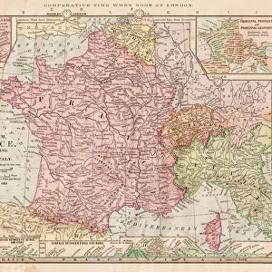
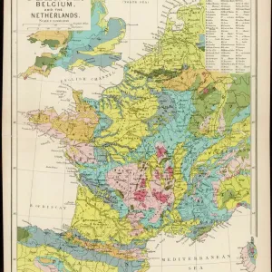
Framed Print : MAP OF FRANCE, c1900. With inset detail of Paris and surrounding area


![]()
Framed Photos from Granger
MAP OF FRANCE, c1900. With inset detail of Paris and surrounding area
Granger holds millions of images spanning more than 25,000 years of world history, from before the Stone Age to the dawn of the Space Age
Media ID 6622393
14"x12" (38x32cm) Modern Frame
Discover the rich history and cultural beauty of France with our exquisite Framed Prints from Media Storehouse, featuring the vintage map of France, c1900, from The Granger Collection. This captivating piece showcases intricate details of the country's geography, borders, and cities, with an inset detail focusing on the iconic Paris and its surrounding area. Perfectly preserved from the early 1900s, this antique map is an essential addition to any home or office decor, transporting you back in time. Bring a touch of history and charm to your space with our Framed Prints by Media Storehouse.
Wood effect frame, card mounted, 10x8 archival quality photo print. Overall outside dimensions 14x12 inches (38x32cm). Environmentally and ozone friendly, 40mm wide x 15mm Polycore® moulding has the look of real wood, is durable and light and easy to hang. Biodegradable and made with non-chlorinated gases (no toxic fumes) it is efficient; producing 100 tons of polystyrene can save 300 tons of trees! Prints are glazed with lightweight, shatterproof, optical clarity acrylic (providing the same general protection from the environment as glass). The back is stapled hardboard with a sawtooth hanger attached. Note: To minimise original artwork cropping, for optimum layout, and to ensure print is secure, the visible print may be marginally smaller
Contemporary Framed and Mounted Prints - Professionally Made and Ready to Hang
Estimated Image Size (if not cropped) is 24.4cm x 19.8cm (9.6" x 7.8")
Estimated Product Size is 37.6cm x 32.5cm (14.8" x 12.8")
These are individually made so all sizes are approximate
Artwork printed orientated as per the preview above, with landscape (horizontal) orientation to match the source image.
FEATURES IN THESE COLLECTIONS
> Arts
> Landscape paintings
> Waterfall and river artworks
> River artworks
> Europe
> France
> Paris
> Maps
> Europe
> France
> Paris
> Related Images
> Maps and Charts
> Early Maps
> Maps and Charts
> Related Images
> Granger Art on Demand
> Maps
EDITORS COMMENTS
This print from Granger Art on Demand showcases a vintage "Map of France, c1900". With its intricate details and historical significance, this piece takes us back in time to the early 20th century. The map features an inset detail of Paris and its surrounding area, allowing us to explore the enchanting capital city's layout during that era. The craftsmanship evident in this French map is truly remarkable. Every river, town, and border is meticulously illustrated with precision and accuracy. It serves as a testament to the cartographic expertise of the time and provides valuable insights into France's geographical landscape at the turn of the century. As we gaze upon this beautiful artwork, our imagination runs wild with thoughts of exploration and adventure. We can almost envision travelers relying on maps like these to navigate their way through picturesque countryside or bustling city streets. This particular map holds immense historical value as it captures a snapshot of France during an important period in its history. "The Map of France, c1900" by The Granger Collection invites us to appreciate both its aesthetic appeal and educational significance. Whether you are a lover of history or simply intrigued by antique maps, this print will undoubtedly add charm and sophistication to any space it graces.
MADE IN THE UK
Safe Shipping with 30 Day Money Back Guarantee
FREE PERSONALISATION*
We are proud to offer a range of customisation features including Personalised Captions, Color Filters and Picture Zoom Tools
SECURE PAYMENTS
We happily accept a wide range of payment options so you can pay for the things you need in the way that is most convenient for you
* Options may vary by product and licensing agreement. Zoomed Pictures can be adjusted in the Basket.