Postcard > Fine Art Finder > Artists > English School
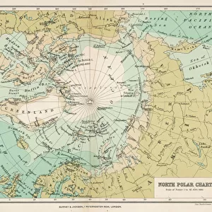
Postcard : Polar Exploration, Chart of the Arctic Regions, showing the Routes of the Expeditions now in Progress and indicating the Most Northerly Points reached by Former Explorers (litho)
")
")

![]()
Cards from Fine Art Finder
Polar Exploration, Chart of the Arctic Regions, showing the Routes of the Expeditions now in Progress and indicating the Most Northerly Points reached by Former Explorers (litho)
1048095 Polar Exploration, Chart of the Arctic Regions, showing the Routes of the Expeditions now in Progress and indicating the Most Northerly Points reached by Former Explorers (litho) by English School, (19th century); Private Collection; (add.info.: Polar Exploration, Chart of the Arctic Regions, showing the Routes of the Expeditions now in Progress and indicating the Most Northerly Points reached by Former Explorers. Illustration for The Graphic, 6 October 1894.); Look and Learn / Illustrated Papers Collection; English, out of copyright
Media ID 22218564
© Look and Learn / Illustrated Papers Collection / Bridgeman Images
Arctic Arctic Regions Chart Expeditions Indicating Polar Exploration Progress Reached Routes Showing
Postcards (8 pack of A6)
Set of 8, A6 Postcards, featuring the same image on all cards in a set. Printed on 350gsm premium white satin card, the back of the postcard includes space to write messages and an area for the address and stamp. Size of each postcard is 15cm x 10.6cm.
Photo postcards are a great way to stay in touch with family and friends.
Estimated Product Size is 10.6cm x 15cm (4.2" x 5.9")
These are individually made so all sizes are approximate
Artwork printed orientated as per the preview above, with landscape (horizontal) or portrait (vertical) orientation to match the source image.
FEATURES IN THESE COLLECTIONS
> Fine Art Finder
> Artists
> English School
> Fine Art Finder
> Temp Classification
> Maps and Charts
> Related Images
EDITORS COMMENTS
This lithograph, titled "Polar Exploration, Chart of the Arctic Regions" takes us back to the 19th century when brave explorers embarked on daring expeditions into the icy unknown. The print showcases a meticulously detailed map that not only depicts the routes of ongoing expeditions but also highlights the most northerly points reached by former adventurers. As we gaze upon this historical artifact, we are transported to a time when exploration and discovery were at their peak. The chart serves as a visual testament to human curiosity and resilience in the face of extreme conditions. It is an invaluable resource for understanding the progress made in Arctic exploration during that era. The engraving's intricate details draw our attention, allowing us to trace each expedition's path through treacherous waters and frozen landscapes. We can almost feel ourselves standing alongside these intrepid individuals as they push further northward, driven by an insatiable thirst for knowledge and adventure. This lithograph not only provides a glimpse into past achievements but also serves as an inspiration for future generations. It reminds us of humanity's unyielding spirit and our capacity to conquer even the harshest environments. As we admire this piece from Bridgeman Images' collection, let it serve as a reminder that there will always be frontiers waiting to be explored and conquered – both within ourselves and in far-flung corners of our planet.
MADE IN THE UK
Safe Shipping with 30 Day Money Back Guarantee
FREE PERSONALISATION*
We are proud to offer a range of customisation features including Personalised Captions, Color Filters and Picture Zoom Tools
SECURE PAYMENTS
We happily accept a wide range of payment options so you can pay for the things you need in the way that is most convenient for you
* Options may vary by product and licensing agreement. Zoomed Pictures can be adjusted in the Basket.